GIS24.net
Geographic Information System
POI database from MEINWOMOmaps


Geographic Information System
POI database from MEINWOMOmaps
Stallhof
/
ADDRESS
 8510 Gemeinde Stainz
Heckenweg
WeiterUrl : https:/ / de.wikipedia.org/ wiki/ Stallhof
UrlLoad : https:/ / yes
WikiText : Stallhof ist eine Gemeinde mit 542 Einwohnern im Bezirk Deutschlandsberg in der Steiermark. Stallhof liegt in der Weststeiermark. Es existieren keine weiteren Katastralgemeinden außer Stallhof. Der Ort war Teil der 1122 entstandenen Mark Steiermark, die 1180 als Herzogtum Steiermark von Bayern getrennt wurde. Ab 1192 wurde das Gebiet durch die Babenberger in Personalunion zwischen sterreich und der Steiermark regiert. Von 1282 bis 1918 stand das Gebiet unter der Herrschaft der Habsburger. Am 6. November 1918 kam der Ort als Teil der Steiermark zur Republik Deutsch-sterreich. Nach der Annexion sterreichs 1938 kam er zum Reichsgau Steiermark, 1945 bis 1955 war er Teil der englischen Besatzungszone in sterreich.
Click for interactive map
..
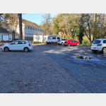
Pictures of the place and surroundings
Videos about the Poi and the surrounding area
.
.
Interesting places in the area
Stainzer Flascherlzug
With the museum railway between Steinz and Preding[ click for more information ]
Parkplatz Ettendorfer Straße
 Beautiful car park at Gamsbad, right next to a road, not very busy at night
usable January - December
[ click for more information ]
Einkaufsparkplatz
[ click for more information ]Spar
[ click for more information ]Schloss Stainz
[ click for more information ]Jagdmuseum und Landwirtschaftsmuseum
in Castle Stainz[ click for more information ]
Parkplatz Schloss Stainz
 The parking lot at Stainz Castle is a fine place to stay and a starting point not only for visiting the castle but also for hikes in the Schilcherland, don´t forget to stop at a wine tavern to try the Schilcher.
 [ click for more information ]
Hofer
[ click for more information ]Billa
[ click for more information ]Stainzer Warte
The 25 m high tower stands on the 608 m high Lethkogel.[ click for more information ]