GIS24.net
Geographic Information System
POI database from MEINWOMOmaps
†


Geographic Information System
POI database from MEINWOMOmaps
†
TŇôebeŇą
/
ADDRESS

WeiterUrl : https:/ / de.wikipedia.org/ wiki/ TŇôebeŇą
UrlLoad : https:/ / yes
WikiText : Tebe (deutsch Trebendorf) ist eine tschechische Gemeinde im Okres Cheb. Das Dorf liegt 4 ,km Ųstlich von Franti°kovy L°znõ links der Eger. Im Ort leben etwa 400 Einwohner. Das alte egerlšndische Dorf wurde 1208 erstmals erwšhnt. Im 14. Jahrhundert wurde eine Festung aufgebaut, von der heute allerdings keine Spuren mehr sichtbar sind. Sehenswert ist die ursprŁnglich gotische Steinkirche. NŲrdlich der Gemeinde befindet sich das Naturreservat Soos. Am sŁdlichen Ortsrand finden sich Reste einer um 1940 errichteten, unvollendeten Reichsautobahntrasse, die nach Osten bis ins Tal des FleiŖenbaches fŁhrt.
Click for interactive map
..
Pictures of the Poi and surroundings
.
Things to see in the area
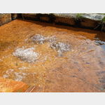
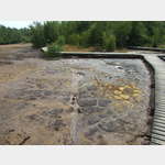
SOOS
[ click for more information ]Naturreservat Soos
 Bog with various active mofettes (īmud volcanoesī) and mineral springs.
 [ click for more information ]
éeleznicnŪ stanice Soos
[ click for more information ]Parkplatz Eger
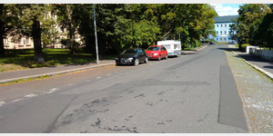 Parking spaces at the roadside.
 [ click for more information ]
St. Nikolaus
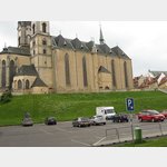 It is a 3-nave basilica from the 13th century.
[ click for more information ]
St. Bartholomšus
It was built by the Crusaders with the Red Star.[ click for more information ]
Bezirksmuseum
It deals with the most important stages of the cityīs history[ click for more information ]
Tschechische BurgenstraŖe
In der Tschechischen Burgenstrasse haben sich Kommunen zu einer touristischen Zusammenarbeit gefunden.[ click for more information ]
Burg Eger
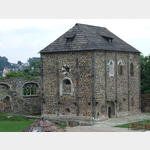 Kaiserpfalz from the 12th century.
[ click for more information ]
Bruecke
The Covered Bridge, MlżnskŠ 32, crosses the Eger near the Imperial Castle.[ click for more information ]