GIS24.net
Geographic Information System
POI database from MEINWOMOmaps


Geographic Information System
POI database from MEINWOMOmaps
Paspels
/
ADDRESS

WeiterUrl : https:/ / de.wikipedia.org/ wiki/ Paspels
UrlLoad : https:/ / yes
WikiText : Paspels (romanisch Pasqual) ist eine politische Gemeinde im Kreis Domleschg im Bezirk Hinterrhein des schweizerischen Kantons Graubünden. Die Gemeinde ist im Verzeichnis der schützenswerten Ortsbilder der Schweiz (ISOS) aufgeführt. Beschreibung: In Silber (Weiss) über grünem Dreiberg ein roter Laurentiusrost. Das Wappenmotiv verweist auf die ehemalige Talkirche Sankt Laurentius. Die Gemeinde liegt auf einer Terrasse über dem rechten Ufer des Hinterrheins am Westhang des Stätzerhorns. Der Ort besteht aus den drei Teilen Canova, Dusch und Pardisla. Vom gesamten Gemeindegebiet von 457 ,ha sind 259 ,ha von Wald und Gehölz bedeckt. Immerhin 152 ,ha können landwirtschaftlich genutzt werden. Daneben gibt es 28 ,ha Siedlungsfläche und 18 ,ha unproduktive Fläche (meist Gebirge). In Paspels wird vorwiegend Viehwirtschaft, Acker-, etwas Obst- und Weinbau betrieben.
Click for interactive map
..
Pictures of the Poi and surroundings
.
Things to see in the area
Raiffeisen Mittelbünden
[ click for more information ]Cazis
[ click for more information ]Aldi
[ click for more information ]Thusis - Nord Raststätte Viamals
 Large parking area with RV and teams
usable 1 January - 31 December
[ click for more information ]
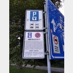
sonstiges
Follow the signs to the ´Thusis petrol station´, within the large parking area an area for mobile homes is marked.[ click for more information ]
Lidl Thusis
[ click for more information ]Autowaschanlage
[ click for more information ]Parkplatz beim Waldschwimmbad
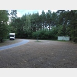 Quiet place in the forest.
 [ click for more information ]
Bahnhof Thusis
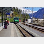 Rhaetian Railway station in Thusis.
 [ click for more information ]
Spital Thusis
Phone: 41 (0)81 632 11 11[ click for more information ]
Parkplatz Skilift Oberurmein
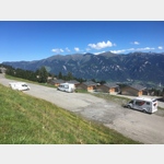 Quiet parking lot in the place of the ski lift.
 [ click for more information ]