GIS24.net
Geographic Information System
POI database from MEINWOMOmaps


Geographic Information System
POI database from MEINWOMOmaps
Oberwald VS
/
ADDRESS

WeiterUrl : https:/ / de.wikipedia.org/ wiki/ Oberwald VS
UrlLoad : https:/ / yes
WikiText : Oberwald war bis zum 31. Dezember 2008 eine politische Gemeinde im Bezirk Goms des Kantons Wallis in der Schweiz. Zur Gemeinde gehörte der nicht ganzjährig bewohnte Weiler Gletsch. Am 25. November 2007 wurde in einer Volksabstimmung eine Fusion der drei Gommer Gemeinden Ulrichen, Obergesteln und Oberwald gutgeheissen. Die neue Gemeinde Obergoms besteht seit dem 1. Januar 2009. Oberwald ist das erste Dorf am Anfang des Goms. Es liegt am Fusse der Alpenpässe Furkapass und Grimsel. Das Dorf wird 1419 erstmals urkundlich erwähnt.
Click for interactive map
..
Pictures of the Poi and surroundings
.
Things to see in the area
besuch
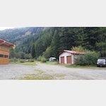
[ click for more information ]Parkplatz am Bahnhof Oberwald
Furka steam railway from Oberwald via Gletsch to RealphClosed from October to May![ click for more information ]
Raiffeisen Oberwald
[ click for more information ]Forest Lodge und Camping
 The former workers´ camp for the construction of the Furkabasis tunnel has been redesigned as a tourist camp with good facilities and is located 100m from the banks of the Rotten (Rhone)
open 1 January - 31 December
[ click for more information ]
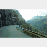
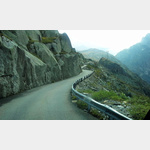
Grimselpass, 2165m 10%
Obergoms Grimsel pass summit[ click for more information ]
Hotel Grimsel Passhöhe
open 07:00-22:00[ click for more information ]
Kristall-Museum
The museum shows crystals from the Aare and Gotthard massifs.[ click for more information ]
Remersee
Der Remersee liegt in der Gemeinde Guttannen im Kanton Bern.[ click for more information ]
Rhone
 After 812 km, the Rhone flows into the Mediterranean Sea.
 [ click for more information ]
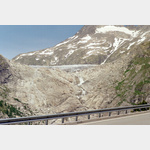
Belvedere sur le Glacier Source du Rhone
A parking lot at the very busy glacier.[ click for more information ]
Die Rhone, von der Quelle bis zur Mündung
From the Rhone Glacier to the Camargue[ click for more information ]