GIS24.net
Geographic Information System
POI database from MEINWOMOmaps


Geographic Information System
POI database from MEINWOMOmaps
Feldis/Veulden
/
ADDRESS

WeiterUrl : https:/ / de.wikipedia.org/ wiki/ Feldis/ Veulden
UrlLoad : https:/ / yes
WikiText : Feldis/Veulden (deutsch und bis 1943 offiziell Feldis, rätoromanisch Veulden) war bis zum 31. Dezember 2008 eine politische Gemeinde im Kreis Domleschg im Bezirk Hinterrhein des Kantons Graubünden in der Schweiz. Seit dem 1. Januar 2009 gehört Feldis/Veulden zusammen mit Trans, Scheid und Tumegl/Tomils zur neuen Gemeinde Tomils. Letzte Gemeindepräsidentin war Ursula Tscharner. Beschreibung: In Silber (Weiss) über rotem Dreiberg ein blauer Greif, rot bewehrt. Der Greif ist das Familienwappen der Tscharner, der Dreiberg weist auf die Höhenlage des Ortes hin.
Click for interactive map
..
Pictures of the place and surroundings
.
Interesting places in the area
Burg Hochjuvalt
[ click for more information ]Burg Hochjuvalt
[ click for more information ]Raiffeisen Feldis / Veulden
[ click for more information ]Burg Oberjuvalt
[ click for more information ]Burg Oberjuvalt
[ click for more information ]Raiffeisen Rhäzüns
[ click for more information ]Parkenpkw
[ click for more information ]Parkplatz Bonaduz
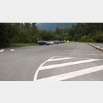 If the power poles at Bonaduz Square (further west) bother you, you can stay here for a maximum of 12 hours.
 [ click for more information ]
Rhein
The Rhine is formed here by the confluence of the Vorderrhein and Hinterrhein.[ click for more information ]
Golfclub Domat Ems
3 x 9-hole course at almost 600m above sea level.[ click for more information ]