GIS24.net
Geographic Information System
POI database from MEINWOMOmaps


Geographic Information System
POI database from MEINWOMOmaps
Techelsberg am Wörther See
/
ADDRESS
 9212 Gemeinde Techelsberg am Wörthersee
WeiterUrl : https:/ / de.wikipedia.org/ wiki/ Techelsberg am Wörther See
UrlLoad : https:/ / yes
WikiText : Techelsberg am Wörther See (slow.: Teholica ob Vrbskem jezeru) ist eine Gemeinde im Bezirk Klagenfurt-Land in Kärnten. Das Gemeindegebiet von Techelsberg reicht über den Südhang der Ossiacher Tauern bis zum Nordufer des Wörthersees. Mit dem Forstsee zählt ein weiterer See zum Gemeindegebiet. Techelsberg ist in die vier Katastralgemeinden St. Bartlmä ( entjernej na Gori), St. Martin am Techelsberg ( martin), Tibitsch (Tibie) und Trabenig-Ebenfeld (Trabene) gegliedert. Das Gemeindegebiet umfasst 17 Ortschaften (in Klammern Einwohnerzahl Stand 2001):
Click for interactive map
..
Pictures of the Poi and surroundings
.
Things to see in the area
Schloss Gradisch
[ click for more information ]Burgruine Leonstein
[ click for more information ]Wörther See
[ click for more information ]Forstsee
Keine Liegewiese vorhanden, nur ein steiniger Uferbereich.[ click for more information ]
Apotheke
St.[ click for more information ]
Bahnhof
Portschach train station[ click for more information ]
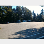
Wohnmobilparkplatz Maria Wörth
Attention Parking is not without danger, colored hard shoulder in a curve.[ click for more information ]
ParkenPkw
Parking for 3-4 motorhomes tolerated at night and a bit noisy otherwise ok[ click for more information ]
Slow Trail Römerschlucht
The Römerschlucht Slow Trail is part of the Wortersee hiking area.[ click for more information ]
Parkplatz am Pyramidenkogel
 Parking lot to go to the Pyramidenkogel lookout tower.
 [ click for more information ]