GIS24.net
Geographic Information System
POI database from MEINWOMOmaps


Geographic Information System
POI database from MEINWOMOmaps
St. Ulrich am Pillersee
/
ADDRESS
 6393 St. Ulrich am Pillersee, St. Adolari
Neuhausweg
WeiterUrl : https:/ / de.wikipedia.org/ wiki/ St. Ulrich am Pillersee
UrlLoad : https:/ / yes
WikiText : St. Ulrich am Pillersee (lokal auch: Nuarach) ist eine Gemeinde mit 1548 Einwohnern im Bezirk Kitzbühel in Tirol, sterreich. St. Ulrich am Pillersee liegt auf 847 Metern Seehöhe am namensgebenden Pillersee im Pillerseetal in der Westabschattung der Loferer Steinberge. Das Gemeindegebiet umfasst 52,0 km, davon sind 7,6 km besiedelt. 23,9 ,% (1243 ha) der Gemeindefläche werden landwirtschaftlich, und zwar vornehmlich zur Viehzucht genutzt. 49,2 ,% der Gemeindefläche, das entspricht 2560 ha, sind mit Wald bedeckt, der überwiegend forstwirtschaftlich genutzt wird. 1,3 ,% (69 ha) sind bebaut, die besiedelt Fläche beträgt 7,6 km, das entspricht 14,6 ,% der Gemeindefläche. Der höchste Punkt der Gemeinde liegt auf 2506 Metern ü. N.N. am Gipfel des großen Hinterhorns (Mitterhorn).
Click for interactive map
..
Pictures of the Poi and surroundings
.
Things to see in the area
Einkaufsmöglichkeit
[ click for more information ]Spar
[ click for more information ]Tagesparkplatz Sankt Ulrich
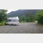 large gravel car park at the entrance to the village with a view of the lake and lighting at night
[ click for more information ]
Piller See
[ click for more information ]Pillersee
[ click for more information ]Familienland Pillersee - Freizeitpark Tirol
[ click for more information ]Wallerberg, 1682m
[ click for more information ]
sonstiges
Disk gas station with gas cylinders[ click for more information ]
Bahnhof
Fieberbrunn train station[ click for more information ]
Wohnmobil-Tagesparkplatz Bergbahnen am Pillersee
The car park at the Bergbahnen am Pillersee offers space for 5 Womos.[ click for more information ]