GIS24.net
Geographic Information System
POI database from MEINWOMOmaps


Geographic Information System
POI database from MEINWOMOmaps
Schlägl
/
ADDRESS
 4160 Gemeinde Schlägl
Am Teich
WeiterUrl : https:/ / de.wikipedia.org/ wiki/ Schlägl
UrlLoad : https:/ / yes
WikiText : Schlägl ist eine Gemeinde in Oberösterreich im Bezirk Rohrbach im oberen Mühlviertel mit 1.391 Einwohnern. Der zuständige Gerichtsbezirk ist Rohrbach in Oberösterreich. Schlägl liegt auf 544 m Höhe im oberen Mühlviertel. Die Ausdehnung beträgt von Nord nach Süd 10,2 km, von West nach Ost 7,6 km. Die Gesamtfläche beträgt 28,6 km. 54,9 ,% der Fläche sind bewaldet, 39,9% der Fläche sind landwirtschaftlich genutzt. Ortsteile der Gemeinde sind: Baureith, Breitenstein, Diendorf, Geiselreith, Kerschbaum, Natschlag, Sankt Wolfgang, Schlägl, Unterneudorf, Weichsberg, Winkl, Wurmbrand.
Click for interactive map
..
Pictures of the Poi and surroundings
.
Things to see in the area
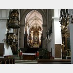
Stift Schlägl
Norbert von Xanten founded the Premonstratensian Order in 1218 at the foot of the Bohemian Forest. [ click for more information ]
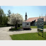
Parkplatz Meierhof Schlägl
 Parking at the event center Meierhof Schlägl
[ click for more information ]
Einkaufsmöglichkeit
[ click for more information ]Spar
[ click for more information ]BP
[ click for more information ]Aigen-Schlägl
[ click for more information ]Vogelmuseum
In 1993 the museum The Bird World of the umava was opened.[ click for more information ]
Billa
[ click for more information ]Kalvarienberg Aigen im Mühlkreis
The Holy Sepulcher and the Way of the Cross Chapel from 1650 are located here.[ click for more information ]