GIS24.net
Geographic Information System
POI database from MEINWOMOmaps


Geographic Information System
POI database from MEINWOMOmaps
Sankt Gotthard im Mühlkreis
/
ADDRESS
 4111 Gemeinde Walding
Obermursberg
WeiterUrl : https:/ / de.wikipedia.org/ wiki/ Sankt Gotthard im Mühlkreis
UrlLoad : https:/ / yes
WikiText : Sankt Gotthard im Mühlkreis ist eine Gemeinde in Oberösterreich im Bezirk Urfahr-Umgebung im oberen Mühlviertel mit 1.329 Einwohnern. Der zuständige Gerichtsbezirk ist Urfahr-Umgebung. Sankt Gotthard im Mühlkreis liegt auf 290 m Höhe im oberen Mühlviertel. Die Ausdehnung beträgt von Nord nach Süd 5,0 km und von West nach Ost 5,0 km. Die Gesamtfläche beträgt 12 km.
Click for interactive map
..
Pictures of the Poi and surroundings
.
Things to see in the area
Schloss Eschelberg
[ click for more information ]Bahnhof Rottenegg
[ click for more information ]Hofer, Walding Kaufpark, Walding, Österreich
[ click for more information ]Friedhof Lacken
[ click for more information ]Schloss Mühldorf
[ click for more information ]Landgasthof Rodlhof
A nice rural inn with good traditional cooking and (in summer) garden.[ click for more information ]
Parkplatz Badeseen
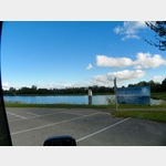 Large parking lot at the bathing lakes, also for the Thalhammers restaurant, which probably has to do without campers due to the general ban on stopping.
 [ click for more information ]
Biergarten
Thalhammers: Restaurant, Cafe, Bar, open April to September, good food, excellent wine list.[ click for more information ]
Badesee Feldkirchen
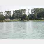 The Feldkirchen bathing lake in Austria is part of a group of five lakes in the municipality of Feldkirchen an der Donau in Upper Austria.
 [ click for more information ]
Parkplatz
Directly on the Danube Cycle Path.[ click for more information ]