GIS24.net
Geographic Information System
POI database from MEINWOMOmaps


Geographic Information System
POI database from MEINWOMOmaps
Mariasdorf
/
ADDRESS
 7433 Gemeinde Mariasdorf
Mariasdorf
WeiterUrl : https:/ / de.wikipedia.org/ wiki/ Mariasdorf
UrlLoad : https:/ / yes
WikiText : Mariasdorf (ungar. M¡riafalva) ist eine Marktgemeinde im südlichen Burgenland in sterreich. berregional bekannt ist Mariasdorf durch die im 15. Jh. erbauten Pfarrkirche Mariae Himmelfahrt, die auch das Gemeindewappen ziert. Zur heutigen Gemeinde Mariasdorf gehören außer dem gleichnamigen Kernort noch vier weitere Dörfer, nämlich Bergwerk, Grodnau, Neustift und Tauchen. Die Gemeinde liegt im südlichen Burgenland im Bezirk Oberwart, etwa 15 km westlich der Staatsgrenze zu Ungarn. Nachbargemeinden sind Oberschützen, Bad Tatzmannsdorf, Stadtschlaining und Bernstein im Burgenland.
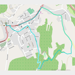
Click for interactive map
..
Pictures of the Poi and surroundings
Videos about the Poi and the surrounding area
.
.
Things to see in the area
Autowaschanlage
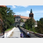
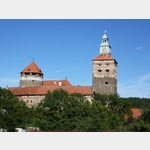
[ click for more information ]Schloss Jormannsdorf
[ click for more information ]Billa
[ click for more information ]Autowaschanlage
[ click for more information ]Freilichtmuseum Bad Tatzmannsdorf
[ click for more information ]Spar
[ click for more information ]Antimonschlössel
[ click for more information ]Planetenweg Bernstein
The planet path illustrates our solar system with the nine planets.[ click for more information ]
Planetenweg Berstein
 The planetary path illustrates our solar system with the nine planets.
 [ click for more information ]
Aussichtswarte Aschau
The tower has a height of 8 m.[ click for more information ]