GIS24.net
Geographic Information System
POI database from MEINWOMOmaps


Geographic Information System
POI database from MEINWOMOmaps
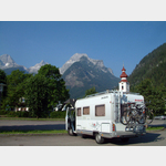
Lofer
/
ADDRESS
 5090 Lofer
B311
WeiterUrl : https:/ / de.wikipedia.org/ wiki/ Lofer
UrlLoad : https:/ / yes
WikiText : Lofer ist eine Marktgemeinde mit 1.943 Einwohnern im österreichischen Bundesland Salzburg, im Pinzgauer Saalachtal gelegen. Bürgermeisterin ist seit 18. März 2004 Bettina Mitterer (VP). Lofer liegt im Pinzgauer Saalachtal, umrahmt von den Gebirgszügen der Loferer und Reither Steinberge, im Norden den Ausläufern der Chiemgauer Alpen. Lofer ist der zentrale Ort des Salzburger Saalachtals, Nachbargemeinden im Tal sind Unken nach dem Kniepass, und St. Martin, Weißbach Richtung Süden. Ortsteile von Lofer sind Kreuzfeld, Scheffsnoth, Faistau, Hallenstein und Au/Mayrberg.
Click for interactive map
..
Pictures of the Poi and surroundings
Videos about the Poi and the surrounding area
.

.
Things to see in the area
Apotheke
[ click for more information ]Zahnarzt
[ click for more information ]Parkplatz mitte Lofer
[ click for more information ]Raiffeisenbank
[ click for more information ]Spar
[ click for more information ]RadMurX
Small fine bike service[ click for more information ]
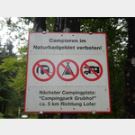
Grubhof Camping
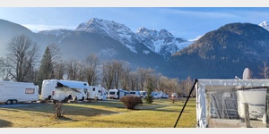 Paid space can be used in Sankt Martin bei Lofer, Salzburg, Austria, January - December Sanitary facilities: Toilets Service: Garbage guarded Sanitary Water Disposal Electricity. Comfortable campsite with different pitch sizes, open in summer and winter
[ click for more information ]
mit dem Fahrrad rund um die Reiter Alpe
 With a length of approx.
 [ click for more information ]
Hundsalmrunde von Lofer
 on a length of approx.
 [ click for more information ]
Rund um Loferer und Leoganger Steinberge
Easy, but approx.[ click for more information ]
Parkplatz Obsthurn
 Parking lot of the natural bathing area Vorderkaser.
 [ click for more information ]