GIS24.net
Geographic Information System
POI database from MEINWOMOmaps


Geographic Information System
POI database from MEINWOMOmaps
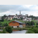
Klaffer am Hochficht
/
ADDRESS
 4163 Gemeinde Klaffer am Hochficht
Dreisesselbergstraße
WeiterUrl : https:/ / de.wikipedia.org/ wiki/ Klaffer am Hochficht
UrlLoad : https:/ / yes
WikiText : Klaffer am Hochficht ist eine Gemeinde in Oberösterreich im Bezirk Rohrbach im oberen Mühlviertel mit 1.318 Einwohnern. Der zuständige Gerichtsbezirk ist Rohrbach in Oberösterreich. Klaffer am Hochficht liegt auf 638 m Höhe im oberen Mühlviertel. Die Ausdehnung beträgt von Nord nach Süd 6,9 km und von West nach Ost 8,6 km. Die Gesamtfläche beträgt 28 km. 59,6 ,% der Fläche sind bewaldet und 37,5% der Fläche sind landwirtschaftlich genutzt. Ortsteile der Gemeinde sind: Freundorf, Holzschlag, Klaffer am Hochficht, Panidorf, Pfaffetschlag, Schönberg, Vorderanger.
Click for interactive map
..
Pictures of the Poi and surroundings
.
Things to see in the area
Friedhof Klaffer
[ click for more information ]Wagnereimuseum
Wagner have been making vehicles for centuries| light to heavy types of wagons, pull and wheelbarrows, pulling equipment, yokes, ploughs, harrows, sleds and toboggans as well as equipment, cider presses, grain shovels, sticks, ice sticks, for agricultural and private use.[ click for more information ]
Water Museum
[ click for more information ]Wagnermuseum
[ click for more information ]Sportanlage Ulrichsberg
A parking lot at the sports facilitiesis usable January - December
[ click for more information ]
Golfpark Bohmerwald Seitelschlag 15
[ click for more information ]Böhmerwaldpark
Open daily from 9:00 a.m.[ click for more information ]
Friedhof Ulrichsberg
[ click for more information ]Eurospar Krieg
[ click for more information ]Glasmuseum
More than 600 exhibits, including a large glass collection, give an insight into the artisan of glass making.[ click for more information ]
Heimathaus
A pull-out house with furnishings is shown.[ click for more information ]