GIS24.net
Geographic Information System
POI database from MEINWOMOmaps


Geographic Information System
POI database from MEINWOMOmaps
Brand-Nagelberg
/
ADDRESS
 3871 Gemeinde Brand-Nagelberg
Hauptstraße
WeiterUrl : https:/ / de.wikipedia.org/ wiki/ Brand-Nagelberg
UrlLoad : https:/ / yes
WikiText : Brand-Nagelberg ist eine Marktgemeinde mit 1.758 Einwohnern im Bezirk Gmünd in Niederösterreich. Brand-Nagelberg liegt im Waldviertel in Niederösterreich. Die Fläche der Marktgemeinde umfasst 36,63 km. 68,22 Prozent der Fläche sind bewaldet. Katastralgemeinden sind Alt-Nagelberg, Brand, Finsternau, Neu-Nagelberg und Steinbach. In Neu-Nagelberg besteht ein Grenzübergang der Europastraße 49 ins tschechische Hal¡mky. Außerdem führt von Finsternau der Wandergrenzübergang Rap¡ach-Sp¡leni¡t/Brand durch die Wälder ins tschechische Mal Londn.
Click for interactive map
..
Pictures of the Poi and surroundings

.
Things to see in the area
Glashütte Apfelthaler
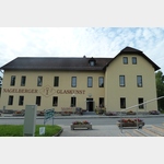 In the Glashütte Apfelthaler you can not only buy glassware but you can also watch glass blowing, grinding, glass painting and engraving.
 [ click for more information ]
Parkplatz, auch zum Übernachten
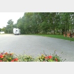 Aspaltierter PP, although situated on the main road, very quiet
is usable January - January
[ click for more information ]
Friedhof
[ click for more information ]Friedhof
[ click for more information ]Teichberg
[ click for more information ]Waldviertlerbahn
With the museum railway on the branch from Alt Nagelsberg to Heidenreichstein[ click for more information ]