GIS24.net
Geographic Information System
POI database from MEINWOMOmaps


Geographic Information System
POI database from MEINWOMOmaps
Apfelberg
/
ADDRESS
 8720 Gemeinde Apfelberg
Lobminger Straße
WeiterUrl : https:/ / de.wikipedia.org/ wiki/ Apfelberg
UrlLoad : https:/ / yes
WikiText : Apfelberg ist eine Gemeinde im Bezirk Knittelfeld in der Steiermark. Apfelberg liegt am Nordfuß des 818 m hohen Gmeinberges. Das Gemeindegebiet erstreckt sich vom Südrand der Stadt Knittelfeld über das Aichfeld mit der Ortschaft Landschach bis zu den Ausläufern der Gleinalpe im Süden. Der tiefste Punkt ist bei 630 m NN an der Mur, der höchste Punkt bei 1178 m. Apfelberg besteht aus der einzigen Katastralgemeinde Apfelberg mit den beiden Ortschaften Apfelberg (191 Einwohner 2001) und Landschach (895).
Click for interactive map
..
Pictures of the Poi and surroundings
.
Things to see in the area
Schlossruine Einödhof
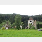 The Einödhof castle ruins in Knittelfeld, Austria, are a fascinating historical landmark.
 [ click for more information ]
Eisenbahnmuseum
The history of the railway, from the mail coach to the Taurus, is brought closer to the visitors here.[ click for more information ]
TouristInfo
MSM CityInfo Opening hours: Mon.[ click for more information ]
Hl. Erzengel Michael und Gabriel
Romanian Orthodox Church[ click for more information ]
Tierarzt
Animal clinic Knittelfeld and veterinary medicine.[ click for more information ]
sonstiges
2220738_Beschreibung[ click for more information ]
Kreuzweg zur Kalvarienberg Sankt Margarethen bei Knittelfeld
The path climbs gently up to the Calvary Chapel.[ click for more information ]
Kalvarienbergkapelle
The Kalvarienberg Chapel is located in Kroisbach, Austria.[ click for more information ]
Wipfelwanderweg
The circular hiking trail has a length of 2.7 km.[ click for more information ]
Tower Power
The double tower stands on the 1194 m high Tremmelberg.[ click for more information ]
Kalvarienkirche am Tremmelberg
The church was built at the end of a Way of the Cross with wayside shrines.[ click for more information ]