GIS24.net
Geographic Information System
POI database from MEINWOMOmaps


Geographic Information System
POI database from MEINWOMOmaps
Zahara de los Atunes
/
ADDRESS
Barbate, Zahara de los AtunesCA-2216
WeiterUrl : https:/ / de.wikipedia.org/ wiki/ Zahara de los Atunes
UrlLoad : https:/ / yes
WikiText : Zahara de los Atunes (atn ist Spanisch für Thunfisch) ist ein kleiner Küstenort an der Costa de la Luz (Spaniens Küste zum Atlantischen Ozean hin) in Andalusien (Südspanien), der als Zentrum des Thunfischfanges bekannt ist. Er gehört zur Provinz C¡diz und zur Gemeinde Barbate Die Lage des Ortes am südlichsten Zipfel der Iberischen Halbinsel in der Nähe von Tarifa (südlichste Stadt Spaniens) und dem englischen Gibraltar lässt bei gutem Wetter eine Aussicht über die Straße von Gibraltar bis nach Tanger in Marokko auf dem afrikanischen Kontinent zu. Nächste größere Städte sind Barbate und C¡diz, sowie etwas weiter Jerez de la Frontera und M¡laga.
Click for interactive map
..
Pictures of the place and surroundings
.
Interesting places in the area
Kirche
[ click for more information ]coche
[ click for more information ]Parkenwomo
[ click for more information ]Parkenwomo
[ click for more information ]Wohnmobil-Strandparkplatz
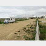 Large parking lot just behind the dunes
is open April - October
[ click for more information ]
100
[ click for more information ]Parkplatz
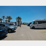 A parking space in front of a parking lot of Hotel Antonio.
[ click for more information ]
Parkenwander
[ click for more information ]Parkenwomo
[ click for more information ]Camping Bahia de la Plata
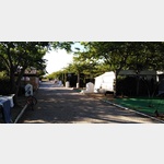 Between the quay and the sea
usable 1 January - 31 December
[ click for more information ]
ParkenAll
[ click for more information ]Playa del Canuelo
Beautiful beach half textile the other nudist.[ click for more information ]