GIS24.net
Geographic Information System
POI database from MEINWOMOmaps


Geographic Information System
POI database from MEINWOMOmaps
Zernez
/
ADDRESS

WeiterUrl : https:/ / de.wikipedia.org/ wiki/ Zernez
UrlLoad : https:/ / yes
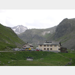
WikiText : Zernez ist eine politische Gemeinde des Kreises Sur Tasna, Bezirk Inn des Kantons Graubünden in der Schweiz. Beschreibung: In Silber (Weiss) ein aufrechter, rot bewehrter schwarzer Bär, eine bewurzelte grüne Tanne tragend. Das Wappen erinnert an die vielen Bärengeschichten aus den Wäldern der Gemeinde. Gleichzeitig verweist es auch auf die Familie Planta, die für die Gemeinde von großer Bedeutung war und eine Bärentatze im Wappen führte. Zernez befindet sich im weiten Talboden des Engadin am Zusammenfluss von Inn und Spöl. Zernez hat 1033 mehrheitlich rätoromanische Einwohner und liegt auf einer Höhe von 1474 ,m. Der Ort ist wichtigster Ausgangspunkt für Wanderungen in den Schweizerischen Nationalpark. Ein beliebtes Ziel ist die Wanderhütte Chamanna Cluozza.
Click for interactive map
..
Pictures of the Poi and surroundings
.
Things to see in the area
Parkplatz
[ click for more information ]Wildenberg Castle
[ click for more information ]Parkplatz, auch zum Übernachten
right on the riveris usable January - January
[ click for more information ]
Raiffeisen Zernez
[ click for more information ]Parkplatz
[ click for more information ]coop
[ click for more information ]Graubündner Kantonalbank
[ click for more information ]sonstiges
[ click for more information ]Waschmaschinen
[ click for more information ]Zernez Camping-Cul
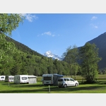 The place is right on the Inn, in the countryside
usable 13 May - 16 October
[ click for more information ]
Parkenwander
[ click for more information ]Chamanna Cluozza
The Chamanna Cluozza is the only hosted hut in the national park.[ click for more information ]