GIS24.net
Geographic Information System
POI database from MEINWOMOmaps


Geographic Information System
POI database from MEINWOMOmaps
Tamins
/
ADDRESS

WeiterUrl : https:/ / de.wikipedia.org/ wiki/ Tamins
UrlLoad : https:/ / yes
WikiText : Tamins (rätoromanisch Tumein) ist eine politische Gemeinde im Kreis Trins, Bezirk Imboden des Kantons Graubünden in der Schweiz. Sie liegt rund 10 km westlich von Chur. Unter dem Schlossfelsen des Ortsteils Reichenau vereinigen sich der Vorder- und Hinterrhein zum Rhein. Im Bahnhof Reichenau-Tamins trennt sich die Eisenbahnlinie der Rhätischen Bahn aus Chur: Eine Linie führt über Thusis ins Engadin, die andere über Disentis nach Andermatt. Beschreibung: Ein Grün ein sechsstrahliger goldener (gelber) Stern. Den Stern zeigte schon ein Gemeindesiegel von 1799. Spätere Wappen zeigten den Stern auch im blauen Feld über grünem Dreiberg.
Click for interactive map
..
Pictures of the Poi and surroundings
.
Things to see in the area
Raiffeisen Tamins
[ click for more information ]Parkenwomo
[ click for more information ]Rhein
The Rhine is formed here by the confluence of the Vorderrhein and Hinterrhein.[ click for more information ]
Bahnhof Reichenau-Tamins
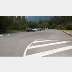
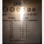 Parking Bahnhof Reichenau-Tamins, per machine, only coins possible!Toilette And restaurant at the station
is usable January - December
[ click for more information ]
Coop
[ click for more information ]Raiffeisen Bonaduz
[ click for more information ]Parkplatz Bonaduz
 If the power poles at Bonaduz Square (further west) bother you, you can stay here for a maximum of 12 hours.
 [ click for more information ]
ParkenAll
[ click for more information ]Kunkelspass 1357 m
[ click for more information ]
Ringelspitzhütte
It is on the southern slope of the Tectonic Arena Sardona and can be reached via Tamins and Vättis.[ click for more information ]
Golfclub Domat Ems
3 x 9-hole course at almost 600m above sea level.[ click for more information ]