GIS24.net
Geographic Information System
POI database from MEINWOMOmaps


Geographic Information System
POI database from MEINWOMOmaps
Wallern an der Trattnach
/
ADDRESS
 4702 Gemeinde Wallern an der Trattnach
Schulstraße
WeiterUrl : https:/ / de.wikipedia.org/ wiki/ Wallern an der Trattnach
UrlLoad : https:/ / yes
WikiText : Wallern an der Trattnach ist eine Marktgemeinde in Oberösterreich im Bezirk Grieskirchen im Hausruckviertel mit 2.905 Einwohnern. Der zuständige Gerichtsbezirk ist Grieskirchen. Wallern an der Trattnach liegt auf 298 m Höhe im Hausruckviertel. Die Ausdehnung beträgt von Nord nach Süd 6,2 km, von West nach Ost 4,6 km. Die Gesamtfläche beträgt 14,7 km. 10,2 ,% der Fläche sind bewaldet, 76,2% der Fläche sind landwirtschaftlich genutzt. Ortsteile der Gemeinde sind: Bergern, Breitwiesen, Edlgassen, Furth, Grub, Haag, Hilling, Holz, Holzhäuser, Hungerberg, Kitzing, Mauer, Müllerberg, Parzham, Uttenthal, Wallern an der Trattnach, Weghof, Winkeln.
Click for interactive map
..
Pictures of the place and surroundings
.
Interesting places in the area
Spar
[ click for more information ]Einkaufsmöglichkeit
[ click for more information ]Hofer
[ click for more information ]Einkaufsmöglichkeit
[ click for more information ]Einkaufsmöglichkeit
[ click for more information ]Billa
[ click for more information ]Mobile home, caravan and caravan site Bad Schallerbach
 Nice pitches - approx
is open 1 January - 31 December
[ click for more information ]
Linzer Strasse , Bad schallerbach, Österreich
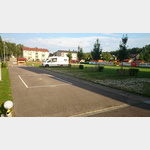
[ click for more information ]Parkplatz bei Gaststätte Krämer in der Au
Gravel parking lot near the restaurant in the middle of agricultural fields.[ click for more information ]
Aquapulco Bad Schallerbach
 A varied and adventurous water world.
[ click for more information ]
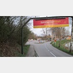
Eurotherme Schallerbach
Large sauna area with heated nudist outdoor pool and sunbathing area.[ click for more information ]