GIS24.net
Geographic Information System
POI database from MEINWOMOmaps


Geographic Information System
POI database from MEINWOMOmaps
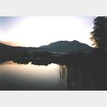
Sankt Kanzian am Klopeiner See
/
ADDRESS
 9122 Sankt Kanzian am Klopeiner See
Tainacher Landesstraße
WeiterUrl : https:/ / de.wikipedia.org/ wiki/ Sankt Kanzian am Klopeiner See
UrlLoad : https:/ / yes
WikiText : Sankt Kanzian am Klopeiner See (slowenisch: kocjan v Podjuni) ist eine Gemeinde im Bezirk Völkermarkt in Kärnten. Sankt Kanzian liegt im Jauntal, südlich der zum Völkermarkter Stausee aufgestauten Drau und ungefähr sieben Kilometer vom Stadtzentrum der Bezirkshauptstadt Völkermarkt entfernt. Zum Gemeindegebiet gehören der Klopeiner See, der Turnersee, der Kleinsee und der Georgiberg. Sankt Kanzian am Klopeiner See ist in sieben Katastralgemeinden gegliedert: Grabelsdorf (Grabalja vas), Lauchenholz (Gluhi les), St. Kanzian ( kocjan), St. Marxen ( marke), St. Veit im Jauntal ( entvid v Podjuni), Srejach (Sreje) und Stein (Kamen).
Click for interactive map
..
Pictures of the Poi and surroundings

Videos about the Poi and the surrounding area
.

.
Things to see in the area
Penny Markt
[ click for more information ]Einkaufsparkplatz
[ click for more information ]Autowaschanlage
[ click for more information ]Supermarkt
[ click for more information ]Spar
[ click for more information ]Apotheke
[ click for more information ]Baumwipfelpfad Klopeiner See
The path runs at a height of 20 m through the treetops.[ click for more information ]
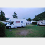
Camping Nord
 OWN TOWN SQUARE - EASY terraced lake resort f
is open February - November
[ click for more information ]
Camping Süd Klopeiner See
 Beautifully situated camp on the south side of the lake
is usable 1 May - 30 September
[ click for more information ]
Bruecke
Bridge over the dam area of the Drau near Völkermarkt[ click for more information ]
Tainach-Stein
Tainach Stein train station[ click for more information ]
Kreuzweg Stein im Jauntal
The path leads past 14 broad-pillar wayside shrines up to the Church of St.[ click for more information ]