GIS24.net
Geographic Information System
POI database from MEINWOMOmaps


Geographic Information System
POI database from MEINWOMOmaps
Rauris
/
ADDRESS
 5661 Gemeinde Rauris
Marktstraße
WeiterUrl : https:/ / de.wikipedia.org/ wiki/ Rauris
UrlLoad : https:/ / yes
WikiText : Rauris ist eine Marktgemeinde im Salzburger Land im Bezirk Zell am See in sterreich mit 3.150 Einwohnern. Die Gemeinde liegt im Pinzgau im Salzburger Land an der Rauriser Ache unterhalb der Sonnblickgruppe im Herzen des Nationalparks Hohe Tauern und erstreckt sich über das Raurisertal. Rauris ist die flächenmäßig größte Gemeinde in Salzburg. Ortsteile sind: Bucheben, Fröstlberg, Grub, Hundsdorf, Marktrevier, Rauris, Seidlwinkl, Unterland, Vorstanddorf, Vorstandrevier, Wörth, Wörtherberg.
Click for interactive map
..
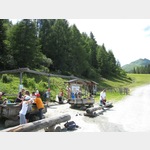
Pictures of the Poi and surroundings
.
Things to see in the area
Friedhof Rauris
[ click for more information ]besuch
[ click for more information ]Stadtbäckerei Martin Kreuzer
[ click for more information ]Wiesenweg
[ click for more information ]Billa
[ click for more information ]Spar
[ click for more information ]Kinderspielplatz
[ click for more information ]Summererpark
[ click for more information ]Zöllnerweg
[ click for more information ]Berghuette
 Hochalm Rauris With the Hochalmbahn to the mountain station (birds of prey demonstration).
 [ click for more information ]