GIS24.net
Geographic Information System
POI database from MEINWOMOmaps


Geographic Information System
POI database from MEINWOMOmaps
Luftenberg an der Donau
/
ADDRESS
 4225 Gemeinde Luftenberg an der Donau
Statzinger Straße
WeiterUrl : https:/ / de.wikipedia.org/ wiki/ Luftenberg an der Donau
UrlLoad : https:/ / yes
WikiText : Luftenberg an der Donau ist eine Gemeinde in Oberösterreich im Bezirk Perg im Mühlviertel mit 3829 Einwohnern. Der zuständige Gerichtsbezirk ist Mauthausen. Luftenberg an der Donau liegt auf 295 m Höhe im Mühlviertel. Die Ausdehnung beträgt von Nord nach Süd 7,2 km, von West nach Ost 3,9 km. Die Gesamtfläche beträgt 16,9 km. 20,1 ,% der Fläche sind bewaldet, 51,5% der Fläche sind landwirtschaftlich genutzt. Ortsteile der Gemeinde sind: Abwinden, Forst, Gröbetsweg, Knierübl, Luftenberg, Pürach, Statzing, Steining. Offizielle Beschreibung des Gemeindewappens: In Rot ein goldener, oben zweimal gezinnter Balken, belegt mit einer blauen Leiste. Die Gemeindefarben sind Rot-Gelb-Rot
Click for interactive map
..
Pictures of the Poi and surroundings
Videos about the Poi and the surrounding area
.
.
Things to see in the area
Linzer Golf Club Am Luftenberg 12
[ click for more information ]Bahnhofstrasse 8 , Sankt georgen an der gusen, Österreich
[ click for more information ]Penny
[ click for more information ]Einkaufsparkplatz
[ click for more information ]Spar
[ click for more information ]Einkaufsparkplatz
[ click for more information ]Kloster Pulgarn
[ click for more information ]Einkaufsparkplatz
[ click for more information ]Einkaufsparkplatz
[ click for more information ]Ruine Spielberg
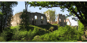 The Spielberg ruins are located in Langenstein, Perg district, in the Mühlviertel in Upper Austria.
 [ click for more information ]