
Europe´s most comprehensive mobile home portal
Over 15 years of experience and quality
by camper drivers for camper drivers


Over 15 years of experience and quality
by camper drivers for camper drivers
SalzAlpenTour - Jochalm - Golling
Tour / hiking / bike / ski / Hiking
SalzAlpenTour - Jochalm - Golling
length: 11.31 km
highest point: 1170 m
lowest point: 505 m
ADDRESS
 5440 Golling an der Salzach
Click for interactive map
..
Images from Poi and starting point surroundings

.
Things worth seeing around the starting point
Gasthof Bärenwirt
[ click for more information ]Schönbachkopf 1870 m
[ click for more information ]Kleiner Göll 1753 m
[ click for more information ]Vorderes Freieck 2142 m
[ click for more information ]Grubenhorn 2230 m
[ click for more information ]Hubertusgrotte
[ click for more information ]Hinteres Freieck
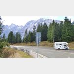
[ click for more information ]Parkplatz Blumtaustrasse
 Parking lot at the beginning of the beautiful Bluntau valley, (must go for a walk or hike) in the summer is charged, otherwise free, is good for resting on the A 10, AB in the front area can be heard at night Arrival: from the A 10 to Golling then over the bridge to Beginning of the Bluntau Valley
[ click for more information ]
Gollinger Wasserfall
[ click for more information ]SalzAlpenSteig 12, Golling - Scheffau
SalzAlpenSteig The hiking trail leads over 233 km from Lake Chiemsee to the Dachstein.[ click for more information ]
Copyright © 2023 - meinwomobuch.com
listed in the mobile home parking space database of meinwomo
listed in the mobile home parking space database of meinwomo