
Europe´s most comprehensive mobile home portal
Over 15 years of experience and quality
by camper drivers for camper drivers


Over 15 years of experience and quality
by camper drivers for camper drivers
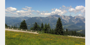
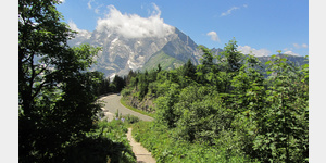
Kuchl - Nesslangeralm - Kuchl
Tour / hiking / bike / ski / Hiking
A circular hiking trail on the Salzalpensteig.
Length: 12 km
Highest point: 1295 m
Lowest point: 457 m
ADDRESS
 5431 Kuchl
Click for interactive map
..
Images from Poi and starting point surroundings
.
Things worth seeing around the starting point
Bruecke Salzach Kuchl
[ click for more information ]See
Bürgerausee Kuchl[ click for more information ]
Torrenerhof
 A connected to a hotel and country inn camping
is usable January - December
[ click for more information ]
Bucht
Nice bathing spot at the Taugl Unterlangenberg 32, 5431, Austria[ click for more information ]
SalzAlpenSteig 12, Golling - Scheffau
SalzAlpenSteig The hiking trail leads over 233 km from Lake Chiemsee to the Dachstein.[ click for more information ]
Parkplatz Blumtaustrasse
 Parking lot at the beginning of the beautiful Bluntau valley, (must go for a walk or hike) in the summer is charged, otherwise free, is good for resting on the A 10, AB in the front area can be heard at night Arrival: from the A 10 to Golling then over the bridge to Beginning of the Bluntau Valley
[ click for more information ]
Allgemeiner Parkplatz
Large village car park next to the school and a supermarket[ click for more information ]
Roßfeldpanoramastraße
Roßfeld Panoramastrasse[ click for more information ]
Bergpass
Roßfeld-Ringstrasse, Austria| (B319) Bad Dürrnberg 1540m 10% toll[ click for more information ]
Wohnmobilstellplatz Salzwelten Hallein
nice salt mine - official day camper park.[ click for more information ]
Ziel
Bad Dürnberg Salt Mine, Ramsaustraße 3, 5422 Bad Dürrnberg, Austria[ click for more information ]
Copyright © 2023 - meinwomobuch.com
listed in the mobile home parking space database of meinwomo
listed in the mobile home parking space database of meinwomo