
Europe´s most comprehensive mobile home portal
Over 15 years of experience and quality
by camper drivers for camper drivers


Over 15 years of experience and quality
by camper drivers for camper drivers
Izvir Soce (Soca-Quelle)
Tour / hiking / bike / ski / Hiking
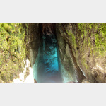
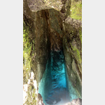
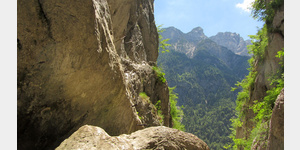
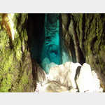
The Soca has its source in the Julian Alps on the southern slope of the Travnik and after about 140 kilometers it flows into the Gulf of Trieste. Its source is a special tourist attraction. A rushing stream springs from a deep crevice filled with deep blue shimmering water, which then plunges down several rock steps. The source can be reached via a marked hiking trail, which in its final phase turns into a via ferrata secured with steel cables and is rather unsuitable for children or people who are afraid of heights. However, those who dare to climb along the steep rock face will be rewarded with a lasting experience.
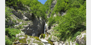
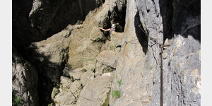
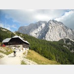
The hiking trail begins at the managed hiker´s hut Koca pri izviru Soce and leads past the hut to the left into the forest. First it´s a leisurely climb, then there are steps in the narrow path that require considerable step heights in some places. The creek can already be seen on the left in the gorge, to which you can climb down at various points via footpaths. In the last fifty meters, the path then turns into a via ferrata, mostly secured with steel cables, which leads along an almost vertical rock face with only narrow treads just before the spring. In addition to sure-footedness, arm strength is required here to overcome the last few meters. From the steel cable, two step irons lead you down onto large stones, over which you reach the crevice after a few steps. Sturdy shoes are strongly recommended.
which require considerable step heights in some places. The creek can already be seen on the left in the gorge, to which you can climb down at various points via footpaths. In the last fifty meters, the path then turns into a via ferrata, mostly secured with steel cables, which leads along an almost vertical rock face with only narrow treads just before the source. In addition to sure-footedness, arm strength is required here to overcome the last few meters. From the steel cable, two step irons lead you down onto large stones, over which you reach the crevice after a few steps. Sturdy shoes are strongly recommended.
which require considerable step heights in some places. The creek can already be seen on the left in the gorge, to which you can climb down at various points via footpaths. In the last fifty meters, the path then turns into a via ferrata, mostly secured with steel cables, which leads along an almost vertical rock face with only narrow treads just before the source. In addition to sure-footedness, arm strength is required here to overcome the last few meters. From the steel cable, two step irons lead you down onto large stones, over which you reach the crevice after a few steps. Sturdy shoes are strongly recommended.
to which you can climb down at various points via footpaths. In the last fifty meters, the path then turns into a via ferrata, mostly secured with steel cables, which leads along an almost vertical rock face with only narrow treads just before the spring. In addition to sure-footedness, arm strength is required here to overcome the last few meters. From the steel cable, two step irons lead you down onto large stones, over which you reach the crevice after a few steps. Sturdy shoes are strongly recommended.
to which you can climb down at various points via footpaths. In the last fifty meters, the path then turns into a via ferrata, mostly secured with steel cables, which leads along an almost vertical rock face with only narrow treads just before the source. In addition to sure-footedness, arm strength is required here to overcome the last few meters. From the steel cable, two step irons lead you down onto large stones, over which you reach the crevice after a few steps. Sturdy shoes are strongly recommended.
to overcome the last meters. From the steel cable, two step irons lead you down onto large stones, over which you reach the crevice after a few steps. Sturdy shoes are strongly recommended.
to overcome the last meters. From the steel cable, two step irons lead you down onto large stones, over which you reach the crevice after a few steps. Sturdy shoes are strongly recommended.
ADDRESS
 Flitsch
Click for interactive map
..
Images from Poi and starting point surroundings
.
Things worth seeing around the starting point
Kek?eva doma?ija
[ click for more information ]Flussquelle
 Just when you come down from the Vrsic pass, there is a small signpost Izviru Soce on the right side.
 [ click for more information ]
Vrsic
[ click for more information ]Mojstrovka
[ click for more information ]Parkenwander
[ click for more information ]Biergarten
 Restaurant with outdoor gastronomy at the highest point of this pass road, good offer in 3 languages, mountain panorama
[ click for more information ]
Passstraße über Vrsic Pass
21 km pass road with breathtaking mountain panorama, 800 m difference in altitude, 40 hairpin bends, intermediate stops: Russian chapel, Vrsic saddle, botanical garden[ click for more information ]
Market Zadruga Trenta
[ click for more information ]ParkenAll
[ click for more information ]Besucherzentrum Trenta-Haus
 As a cultural center with a museum, the Trenta House offers a lot of information for visitors to the national park.
 [ click for more information ]
Copyright © 2023 - meinwomobuch.com
listed in the mobile home parking space database of meinwomo
listed in the mobile home parking space database of meinwomo