
Europe´s most comprehensive mobile home portal
Over 15 years of experience and quality
by camper drivers for camper drivers


Over 15 years of experience and quality
by camper drivers for camper drivers
Wanderung zum Njupeskärs vattenfall
Tour / hiking / bike / ski / Hiking
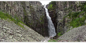
About twenty kilometers south-west of Särna, the route leads up to the Fulufjället plateau, the highest peaks of which are over one thousand meters high. Sweden´s highest waterfall can be found at its north-eastern foothills near the small town of Mörkret. The waters of the Njupån tumble down 93 meters from the plateau and form the Njupeskär. The fall is located in Fulufjället National Park, established in 2002, and is visited by numerous tourists. Over the millennia, the river has dug deep into the rocks here and the progressive erosion of the rock notch continues.
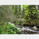
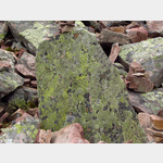
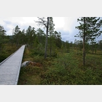
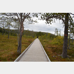
The waterfall is a 2km hike from a hiker´s car park at Fulufjället National Park Visitor Centre. First the path leads through flat, swampy terrain with embedded lakes. After about 1200 meters, the Njupån is crossed on a wooden bridge. The narrow path now leads uphill on the left side of the river slope. 500 meters further, a path branches off to the right, which takes you to the plateau and the head of the waterfall. The path to the foot of Njupeskär now crosses the river again on a wooden bridge and on wooden footbridges it goes the last 200 meters on the right side of the river to a viewing platform, which is about 100 meters before the fall. You can return from the end of the wooden footbridge on the right side of the valley. You cross extensive block heaps, the stones of which are extensively overgrown with the yellow-green map lichen. These lichens only grow about a millimeter in 10 years, so that large specimens can be over 1000 years old.
ADDRESS
79090 FulufjälletW 1067
Route : Am Besucherzentrum sind Informationstafeln einschließlich Karten des Gebietes aufgestellt, auf denen man sich über die Wanderung informieren kann. Desweiteren besteht die Möglichkeit, sich auch im Naturum selbst über Natur und Kultur des Parks zu informieren oder an geführten Wanderungen teilzunehmen. Der Wanderpfad ist als Lehrpfad ausgelegt und touristisch gut erschlossen, so dass es kaum Orientierungsschwierigkeiten geben dürfte.
Click for interactive map
..
Pictures of the place and surroundings
Videos about the Poi and the surrounding area
.
.
Interesting places in the area
Tagesparkplatz
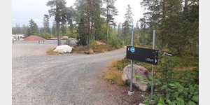 Day parking at Naturum Fulufjällets National Park with Sweden´s highest waterfall
 [ click for more information ]
Naturum
[ click for more information ]Gammalfjällshöa
[ click for more information ]Njupeskär Wasserfall
 The Nnupeskär waterfall is 125 m high, of which 90 m in free fall, the highest waterfall in Sweden and is located in the Fulufjället National Park.
 [ click for more information ]
Njupskärs Vattenfall
[ click for more information ]Njupeskär
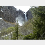 At 125 meters high, 90 meters of it in free fall.
 [ click for more information ]
Fluß Fulan
[ click for more information ]Övra Trollsjön
[ click for more information ]
Copyright © 2023 - meinwomobuch.com
listed in the mobile home parking space database of meinwomo
listed in the mobile home parking space database of meinwomo