
Europe´s most comprehensive mobile home portal
Over 15 years of experience and quality
by camper drivers for camper drivers


Over 15 years of experience and quality
by camper drivers for camper drivers
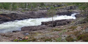
Trollforsen Insel-Rundwanderung
Tour / hiking / bike / ski / Hiking
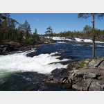
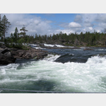
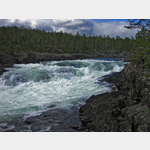
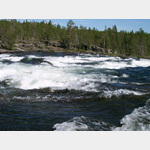
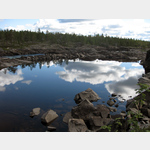
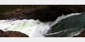
Northwest of Moskosel, the Pieteälven forms the Trollforsen, one of the largest rapids in Europe. The river´s waters were once used to transport logs from the forests of northern Sweden to the shores of the Gulf of Bothnia. The remains of the bank fortifications used for this purpose can still be seen today. Perhaps the best way to experience the power of water is to take a circular walk around a large island surrounded on both sides by the river´s rapid cascades. The circular hike runs on narrow trails through sparse pine forest, partly over open rock and through swampy valleys. In many places you can walk right up to the river, which sometimes flows at breakneck speed one to two meters below the cliff edge. On the way there are also individual shelters, where you can take a little break. The route is about 6 km long. In order to have enough time for photo stops and shore visits, you should plan at least 3 hours. Sturdy shoes are recommended for the hike. Hiking sticks are not essential, but can be very useful when overcoming obstacles.
ADDRESS
981 92Route : Etwa 300 m oberhalb des Stellplatzes führt eine schwankende Hängebrücke über den linken Arm des Flusses auf die Insel hinüber. Bereits von hier ist das in Kaskaden herabstürzende Wasser beindruckend anzuschauen. Man überquert die Hängebrücke und wendet sich nach rechts, wo ein Trampelpfad mal nahe des Flussufers mal etwas weiter weg am Fluss entlangführt. Diesem Pfad folgt man flussaufwärts. Hin und wieder geht es über vom Wasser glatt gewaschenen Fels zwischen dem sich auch Wasserlöcher und Sumpfstellen befinden. Meist ist der Pfad schnell wiedergefunden, wenn man nach den gelben Markierungen an den Stämmen der Bäume Ausschau hält. Im oberen Teil der Insel gibt es mehrere, kaum wahrnehmbare Pfade, auf denen man zur gegenüber liegenden Seite der Insel wechseln kann. Hier geht es am rechten Arm des Flusses wieder flussabwärts. Dieser Arm ist schmaler die Wucht des Wassers dafür noch größer. Auf nahezu gleicher Höhe wird auch dieser Flussarm von einer Hängebrücke überquert. Erreicht man diese, wendet man sich wieder Richtung Inselmitte und erreicht bald darauf den Ausgangspunkt der Wanderung.@
Click for interactive map
..
Pictures of the place and surroundings


.
Interesting places in the area
Trollforsen Norra
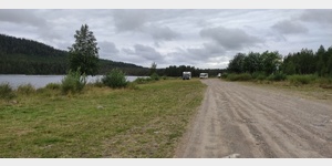 Free camping on a former campsite directly on the lake-like river Piteälven with nearby rapids worth seeing and many fire pits (bring wood as it is hard to find locally), dry toilet, fresh water from an enclosed spring
open 1 January - 31 December
[ click for more information ]
Entlang des Piteälven zur Piteälvsbron
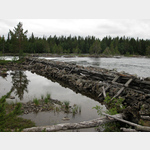 Hiking down the Piteälven from Trollforsen is not as spectacular as the rapids of Trollforsen itself - but there are still interesting views of other rapids and especially old bank fortifications, which the raftsmen used to transport the wood towards the coast 50 years ago.
 [ click for more information ]
Landschaft
 Rapids for about 3 km on both sides of the island.
 [ click for more information ]
Kuotelesjaure
[ click for more information ]
Copyright © 2023 - meinwomobuch.com
listed in the mobile home parking space database of meinwomo
listed in the mobile home parking space database of meinwomo