GIS24.net
Geographic Information System
POI database from MEINWOMOmaps


Geographic Information System
POI database from MEINWOMOmaps
Rhone
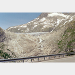
Sight / River head
After 812 km, the Rhone flows into the Mediterranean Sea. 43. 334167, 4. 844167. The lake at the edge of the Rhone glacier is the start.
ADDRESS
Click for interactive map
..
Pictures of the Poi and surroundings
Routes and books with this POI
Die Rhone, von der Quelle bis zur Mündung
.
Things to see in the area
Die Rhone, von der Quelle bis zur Mündung
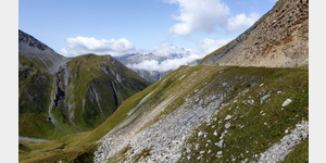
From the Rhone Glacier to the Camargue[ click for more information ]
Belvedere sur le Glacier Source du Rhone
A parking lot at the very busy glacier.[ click for more information ]
Parkplatz Furkastrasse
 A small parking lot with bumps that wedges can be corrected
is open 1 January - 31 December
[ click for more information ]
Remersee
Der Remersee liegt in der Gemeinde Guttannen im Kanton Bern.[ click for more information ]
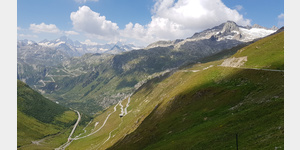
Furkapass, 2431m 14%
Obergoms Furkastrasse [ click for more information ]
Sidelensee
The Sidelensee lies below the Sidelen glacier at 2674 meters.[ click for more information ]
Sidelenhütte
The Sidelenhütte is at the foot of the Galenstock at 2708 m in high alpine terrain.[ click for more information ]
Hotel Grimsel Passhöhe
open 07:00-22:00[ click for more information ]
Obere Schwärziseeli
Das Obere Schwärziseeli ist das grösste der drei Schwärziseen auf dem Gemeindegebiet von Realp im Kanton Uri.[ click for more information ]
Grimselpass, 2165m 10%
Obergoms Grimsel pass summit[ click for more information ]
Mittleres Schwärziseeli
Das mittlere Schwärziseeli ist eines von drei nebeneinander liegenden Bergseelein auf einem Hochplateau südlich des Furkapasses.[ click for more information ]
Parkplatz am Bahnhof Oberwald
Furka steam railway from Oberwald via Gletsch to RealphClosed from October to May![ click for more information ]