GIS24.net
Geographic Information System
POI database from MEINWOMOmaps


Geographic Information System
POI database from MEINWOMOmaps
Bucht von Kotor
Sea / Sea
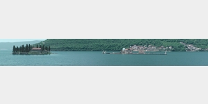
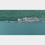
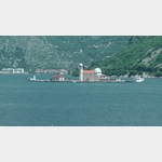
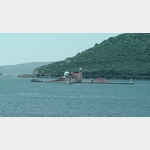
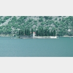
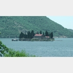
30.01.2014: With its four deep into the mainland basin of the Bay of Kotor is the only fjord in the Mediterranean.. He clings to the almost vertical ascending slopes. | @ The Embankment with its only 70 km in length leads past palm trees, small beaches, picturesque places, as well as to the two ancient towns of Perast and Kotor. @ @ A special attraction in the Bay of Kotor are the two church islands Gospa od Skrpjela and Sveti Dorde. @ @ Gospa od Skrpjela (woman from the rock) is an artificial island, which is gradually created by a bulwark of rocks and by ancient sunken ships were laden with stones .. Gospa od Skrpjela originated in 1452 as a rock on a first church was built.. Every year on 22. July festival takes place Fasinada called when the locals throw stones into the sea so as to cause an enlargement of the island´s land area. @ @ On Sveti Dorde (St. George) is, among others, from the 12th. Century derived Benedictine monastery and a cemetery for the nobility from Perast and lying on the bay communities remaining.
ADDRESS

Click for interactive map
..
Pictures of the Poi and surroundings
.
Things to see in the area
Crkva svetog %u0110or%u0111a
[ click for more information ]Waschsalon beim Suoermarkt, gute Parkmöglichkeit
[ click for more information ]SILVER MOON
[ click for more information ]DOM ZDRAVLJA KOTOR
[ click for more information ]Aroma
[ click for more information ]Sv. Nikole
 The Orthodox Cathedral was built only in 1909, since the 17th century church was destroyed.
[ click for more information ]
Sv. Luka
 The Church of St.
 [ click for more information ]
Kotor
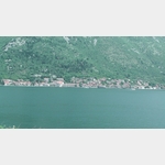
 Kotor, located at the south-eastern tip of the Kotor Bay, was decisively shaped by the Venetians.
 [ click for more information ]
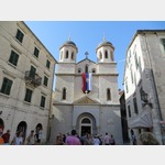
Sv. Tripun
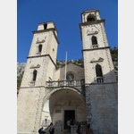 Since Andrija Saracenis acquired the relics of St.
 [ click for more information ]
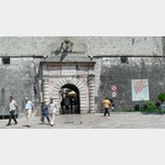
Festung Sveti Ivan
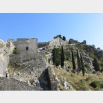 1426 steps lead to the fortress of Sv.
 [ click for more information ]