GIS24.net
Geographic Information System
POI database from MEINWOMOmaps


Geographic Information System
POI database from MEINWOMOmaps
Forth Road Bridge
/
ADDRESS
 KY11 North Queensferry
WeiterUrl : https:/ / de.wikipedia.org/ wiki/ Forth Road Bridge
UrlLoad : https:/ / yes
WikiText : Die Forth Road Bridge ist eine Autobahnbrücke über den Firth of Forth bei Edinburgh in Schottland. Die Brücke wurde zwischen 1958 und 1964 erbaut und war damals die größte Brücke ihrer Art in Europa. Sie ist gut 2,5 Kilometer lang und überspannt den Meeresarm zwischen den Orten North Queensferry und South Queensferry. Die Brücke besteht aus insgesamt fast 47.000 Tonnen Stahl (inklusive der fast 50.000 Kilometer Drahtseil in der Aufhängung). Das britische Königspaar gab am 4. September 1964 das Bauwerk für den Verkehr frei.[1] Vor der Eröffnung der Brücke verkehrten Fähren auf der Strecke, zuletzt hatten sie ein Aufkommen von 600.000 Autos, 200.000 Lastwagen und 1,5 Millionen Menschen pro Jahr zu bewältigen. Wer die Fähre umfahren wollte, musste den großen Umweg über die Kincardine Bridge in Kauf nehmen. Seit April 2001 steht die Forth Road Bridge unter Denkmalschutz.
Click for interactive map
..
Pictures of the Poi and surroundings
.
Things to see in the area
Beamer Rock Lighthouse
[ click for more information ]Shell (Forth Road Bridge) (F) South Queensferry (EDINBURGH)/24h/Credit Cards/EUR
[ click for more information ]Einkaufsmöglichkeit
[ click for more information ]Supermarkt-Tankstelle
[ click for more information ]Ladestation
[ click for more information ]Tesco
[ click for more information ]South Queensferry
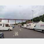 Parking lot right on the water with a great view of the huge old Einsenbahn bridge
open -
[ click for more information ]
Co-op Food
[ click for more information ]Einkaufsmöglichkeit
[ click for more information ]Tesco
[ click for more information ]Parkplatz Hilton Road
Car park on the edge of a residential area, ideal for approaching Edinburgh How to get there: over the Fort Bridge towards the harbour[ click for more information ]