GIS24.net
Geographic Information System
POI database from MEINWOMOmaps


Geographic Information System
POI database from MEINWOMOmaps
Taminatal
/
ADDRESS
 Pfäfers
Ausserdorf
WeiterUrl : https:/ / de.wikipedia.org/ wiki/ Taminatal
UrlLoad : https:/ / yes
WikiText : Das Taminatal (oder Vättnertal) ist ein Seitental des alpinen Rheintals und wird von der Tamina entwässert. Es liegt grösstenteils im Kanton St. Gallen, ein kleiner Teil im Kanton Graubünden. Von Bad Ragaz über eine nord- oder südlich gelegene Serpentine erreichbar, öffnet sich ein schmales Tal mit mehreren kleinen Bergdörfern, wie Pfäfers (Gemeindeverwaltung), Valens, Vadura, Vasön oder Vättis. Das Taminatal verläuft von Bad Ragaz aus südlich in Form einer Mondsichel und spaltet sich in Vättis in zwei weitere Täler auf. Das eine führt südlich über den Kunkelspass ins Rheintal nach Tamins, das andere erstreckt sich westlich als Calfeisental mit der Berggruppe um den Piz Sardona, dem Gigerwaldsee und dem Walserdorf St. Martin.
Click for interactive map
..
Pictures of the place and surroundings
.
Interesting places in the area
Raiffeisen Vättis
[ click for more information ]Drachenloch-Museum
It shows prehistoric finds from the Drachenloch, a cave above Vättis, where Paleolithic hunters had their summer camp around 53',000 years ago.[ click for more information ]
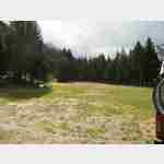
Dunkler Stein
 Popular Picknikplatz to which you can also easily stand overnight
is usable January - December
[ click for more information ]
Parkenwomo
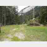
[ click for more information ]Hüttenwies
 Very beautiful place, which is used in part of camp groups
usable April - October
[ click for more information ]
Parkenwomo
[ click for more information ]Mapraggsee
Der Mapraggsee liegt im Taminatal auf einer Höhe von 865 Metern über Meer.[ click for more information ]
Parkenwander
[ click for more information ]Calandahütte
SAC hut, Rätia section on the way to Haldensteiner Calanda.[ click for more information ]