GIS24.net
Geographic Information System
POI database from MEINWOMOmaps


Geographic Information System
POI database from MEINWOMOmaps
Egerbecken
/
ADDRESS

WeiterUrl : https:/ / de.wikipedia.org/ wiki/ Egerbecken
UrlLoad : https:/ / yes
WikiText : Das Egerbecken, auch Egerer Becken (tschechisch Chebsk¡ p¡nev) ist ein Naturraum in Tschechien, benannt nach der etwa in seiner Mitte liegenden Stadt Cheb. Es hat eine Ausdehnung von 271 km. Der höchste Punkt ist mit 534 m der Doubravsk vrch. Die geologische Formation des Egerer Beckens entstand zwischen dem Jungtertiär und älteren Quartär vor etwa 2,7 Millionen bis 850.000 Jahren am Boden eines damals ausgetrockneten Sees. Der Boden besteht größtenteils aus Granitoiden. Die erste Besiedlung des Egerer Beckens begann etwa 3000 Jahre vor der Zeitrechnung. Den Illyrern und Kelten folgten die germanischen Stämme der Hermunduren, der Vandalen und Markomannen. Etwa zu Beginn der Zeitrechnung kam es zur ersten Besiedlung. Begrenzt wird das Egerbecken von Elstergebirge und Erzgebirge im Norden, dem Falkenauer Becken und dem Kaiserwald im Osten, dem Vorland des Oberpfälzer Waldes im Südosten, dem Oberpfälzer Wald im Süden und dem Fichtelgebirge im Westen.
Click for interactive map
..
Pictures of the Poi and surroundings
Videos about the Poi and the surrounding area
.
.
Things to see in the area
Parkplatz, auch zum Übernachten
 Place 24h open, 20, -Kc / hour , Parking ticket machine (only for coins!), Frequent checks, if necessary fixing the vehicle with a claw!
 open January - December
[ click for more information ]
Hl. Olga
The Russian Orthodox Church was built in 1887-89.[ click for more information ]
Heilig Kreuz
Built in 1819 in the Empire style, it was redesigned around 1936.[ click for more information ]
Parkplatz Ladislav Spacil
A parking lot behind the Behemia 1 restaurantusable January - December
[ click for more information ]
Parkplatz an der Luisenquelle
The Luisenquelle is closed.[ click for more information ]
?
guarded and paid PP[ click for more information ]
Via Poeta XVII, Franzensbad CZ - Waldsassen
Ecumenical pilgrimage route from the Volkenroda monastery to the Waldsassen monastery Stage XVII Franzensbad cz - Waldsassen Route length 24 km.[ click for more information ]
Komorní Hurka
Kammerbuehl, 504 m[ click for more information ]
St. Bartholomäus
It was built by the Crusaders with the Red Star.[ click for more information ]
Tschechische Burgenstraße
In der Tschechischen Burgenstrasse haben sich Kommunen zu einer touristischen Zusammenarbeit gefunden.[ click for more information ]
Bruecke
The Covered Bridge, Mlýnská 32, crosses the Eger near the Imperial Castle.[ click for more information ]
Burg Eger
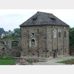 Kaiserpfalz from the 12th century.
[ click for more information ]
St. Nikolaus
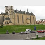 It is a 3-nave basilica from the 13th century.
[ click for more information ]
Bezirksmuseum
It deals with the most important stages of the city´s history[ click for more information ]
Parkplatz Eger
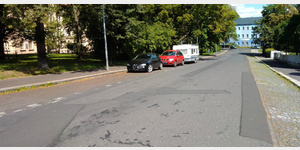 Parking spaces at the roadside.
 [ click for more information ]
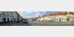
Marktplatz
The market square in the center of the old town of Eger / Cheb. [ click for more information ]
TouristInfo
Touristinfo at the market square of Eger.[ click for more information ]
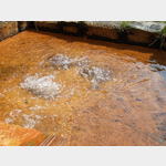
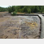
Naturreservat Soos
 Bog with various active mofettes (´mud volcanoes´) and mineral springs.
 [ click for more information ]