GIS24.net
Geographic Information System
POI database from MEINWOMOmaps


Geographic Information System
POI database from MEINWOMOmaps
Untertauern
/
ADDRESS
 5561 Gemeinde Untertauern
B99
WeiterUrl : https:/ / de.wikipedia.org/ wiki/ Untertauern
UrlLoad : https:/ / yes
WikiText : Untertauern ist eine Ortsgemeinde im Bezirk St. Johann im Pongau im Salzburger Land in sterreich. Die Gemeinde liegt im Pongau im Salzburger Land an der Nordseite des Radstädter Tauernpasses, im Tal der Pongauer Taurach. Teilorte sind Untertauern und Obertauern, wobei allerdings ein Teil von Obertauern auch zur Gemeinde Tweng gehört.
Click for interactive map
..
Pictures of the Poi and surroundings
.
Things to see in the area
Fischerhütte
[ click for more information ]Gasthof Zur Post
[ click for more information ]Gasthof Hotel Lürzerhof
[ click for more information ]Gemeindeamt Untertauern
[ click for more information ]Pfarrkirche Untertauern
[ click for more information ]Wild- und Erlebnispark Untertauern
Nature park with free entry, rental of fishing rods and boats, self-caught fish can be grilled/smoked on site.[ click for more information ]
Tagesparkplatz Hotel Post/ Wildpark
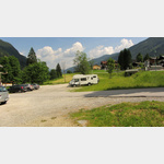 At the end or at the beginning of the Tauern Pass, a simple day car park next to a wildlife park.
 [ click for more information ]
Wild- und Erlebnispark Untertauern
[ click for more information ]Strimskogel
Summit Strimskogel[ click for more information ]
Vorderes Labeneck
Front Labeneck 1832m[ click for more information ]