GIS24.net
Geographic Information System
POI database from MEINWOMOmaps


Geographic Information System
POI database from MEINWOMOmaps
Urmein
/
ADDRESS

WeiterUrl : https:/ / de.wikipedia.org/ wiki/ Urmein
UrlLoad : https:/ / yes
WikiText : Urmein (rätoromanisch Urmagn) ist eine politische Gemeinde im Kreis Thusis im Bezirk Hinterrhein des Kantons Graubünden in der Schweiz. Beschreibung: In Rot ein halber goldener (gelber) Löwe mit goldenem Pfeil in der rechten Pranke. Abwandlung des Wappens der Familie Dönz die den Löwen mit dem Pfeil im blauen Feld führte. Die Farben richten sich nach dem alten Gerichtswappen des Heinzenbergs. Urmein ist ein Haufendorf am Heinzenberg und liegt westlich von Thusis. Südlich des Dorfs fliesst der Nolla durch ein tief eingeschnittenes Tobel und westlich davon erhebt sich der Glaser Grat (2124 ,m). Jenseits des Nollatobels steigt das Gemeindegebiet bis in die Nähe des Zwölfihorns (2281 m) an. Zu Urmein gehört auch das Feriendorf Oberurmein (1527-1609 m).
Click for interactive map
..
Pictures of the place and surroundings
.
Interesting places in the area
Migros
[ click for more information ]Raiffeisen Thusis
[ click for more information ]Spital Thusis
Phone: 41 (0)81 632 11 11[ click for more information ]
coop
[ click for more information ]Bahnhof Thusis
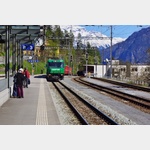 Rhaetian Railway station in Thusis.
 [ click for more information ]
sonstiges
[ click for more information ]TCS Camping Thusis - Viamala
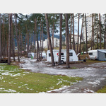 Very nice newly revised course
usable January - December
[ click for more information ]
Parkplatz beim Waldschwimmbad
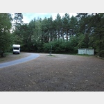 Quiet place in the forest.
 [ click for more information ]
sonstiges
Follow the signs to the ´Thusis petrol station´, within the large parking area an area for mobile homes is marked.[ click for more information ]
Parkplatz Nislas 104
 Place near the famous and worth seeing church (with museum) of Zilis at the end of Via Mala, starting point for hikes Arrival: Coming from Germany: Exit Via Mala Busparkplatz
[ click for more information ]
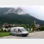
Parkplatz Skilift Oberurmein
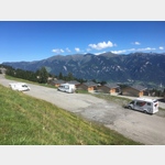 Quiet parking lot in the place of the ski lift.
 [ click for more information ]