GIS24.net
Geographic Information System
POI database from MEINWOMOmaps


Geographic Information System
POI database from MEINWOMOmaps
Schmitten GR
/
ADDRESS

WeiterUrl : https:/ / de.wikipedia.org/ wiki/ Schmitten GR
UrlLoad : https:/ / yes
WikiText : Schmitten (GR), rätoromanisch Ferrera, ist eine politische Gemeinde im Kreis Belfort des Bezirks Albula im Kanton Graubünden in der Schweiz. Die Gemeinde Schmitten ist traditionell deutschsprachig. Die vier anderen Gemeinden des Kreises Belfort sind Brienz/Brinzauls, Surava, Alvaneu und Lantsch/Lenz. Beschreibung: In Blau goldenes Zepter, gekreuzt mit goldenem Bischofsstab. Attribute des heiligen Luzius in den Farben des Zehngerichtenbundes als Hinweis auf die alte Luziuskirche.
Click for interactive map
..
Pictures of the Poi and surroundings
.
Things to see in the area
Rüti Ranch
1/2 day or 2 day tours in the Albula Valley/Grisons.[ click for more information ]
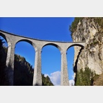
Landwasserviadukt
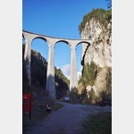 The Albula Railway (UNESCO World Heritage Site) crosses this arched bridge made of dark limestone.
 [ click for more information ]
Campingplatz Islas
A beautifully located campsite at an altitude of approxopen 1 April - 31 October
[ click for more information ]
Parkenwander
[ click for more information ]Filisur
[ click for more information ]Parkplatz am Landwasserviadukt
 Unpaved car park to visit the Landwasser Viaduct.
 [ click for more information ]
Parkenpkw
[ click for more information ]Golf Club Alvaneu
18 hole course at almost 1000m.[ click for more information ]
Schaftobelfall
Der Schaftobelfall ist von Alvaneu Bad oder Surava erreichbar.[ click for more information ]
Ramozhütte
It lies at the foot of the Erzhorn above Arosa on Alp Ramoz at an altitude of 2293 m above sea level.[ click for more information ]
Furcletta
With a pass height of 2573 m, it connects Arosa in Schanfigg with Alvaneu and Schmitten GR in the Albula Valley[ click for more information ]