GIS24.net
Geographic Information System
POI database from MEINWOMOmaps


Geographic Information System
POI database from MEINWOMOmaps
Rongellen
/
ADDRESS

WeiterUrl : https:/ / de.wikipedia.org/ wiki/ Rongellen
UrlLoad : https:/ / yes
WikiText : Rongellen (rätoromanisch Runc¡glia, Runtgaglia bzw. Runtgiaglia) ist eine politische Gemeinde im Kreis Schams, Bezirk Hinterrhein des Kantons Graubünden in der Schweiz. Beschreibung: In Gold (Gelb) eine gestürzte blaue Spitze, belegt mit einer silbernen Bogenbrücke. Heraldische Darstellung der von Brücken überspannten Via Mala. Nachbargemeinden von Rongellen sind Lohn, Thusis, Sils im Domleschg und Zillis-Reischen. Rongellen ist seit einigen Jahren (ca. 1999) die Gemeinde mit dem tiefsten Steuerfuss in Graubünden. Er beträgt 33 1/3% der einfachen Kantonssteuer.
Click for interactive map
..
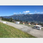
Pictures of the place and surroundings
.
Interesting places in the area
Restaurant und Camping Rania
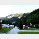 A campsite by a restaurant on the National Road 13, on the Via Mala circular route and the beginning of the gorge
is usable 1 January - 31 December
[ click for more information ]
Migros
[ click for more information ]Raiffeisen Thusis
[ click for more information ]Spital Thusis
Phone: 41 (0)81 632 11 11[ click for more information ]
sonstiges
[ click for more information ]Parkplatz Nislas 104
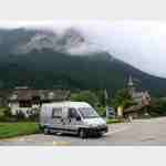 Place near the famous and worth seeing church (with museum) of Zilis at the end of Via Mala, starting point for hikes Arrival: Coming from Germany: Exit Via Mala Busparkplatz
[ click for more information ]
Coop Pronto
[ click for more information ]Bahnhof Thusis
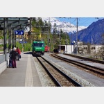 Rhaetian Railway station in Thusis.
 [ click for more information ]
Parkplatz beim Waldschwimmbad
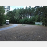 Quiet place in the forest.
 [ click for more information ]
sonstiges
Follow the signs to the ´Thusis petrol station´, within the large parking area an area for mobile homes is marked.[ click for more information ]
Parkplatz Skilift Oberurmein
 Quiet parking lot in the place of the ski lift.
 [ click for more information ]