GIS24.net
Geographic Information System
POI database from MEINWOMOmaps


Geographic Information System
POI database from MEINWOMOmaps
Pignia
/
ADDRESS

WeiterUrl : https:/ / de.wikipedia.org/ wiki/ Pignia
UrlLoad : https:/ / yes
WikiText : Pignia (deutsch und bis 1952 Pignieu) war bis zum 31. Dezember 2008 politische Gemeinde im Kanton Graubünden, Schweiz. Sie gehört zum Kreis Schams im Bezirk Hinterrhein. Auf den 1. Januar 2009 hat Pignia mit Clugin und Andeer zur Gemeinde Andeer fusioniert. Beschreibung: In Gold (gelb) auf grünem Dreiberg ein roter Brunnenstock mit beidseitigem schwarzen Wasserstrahl. Umsetzung des Namens der Fontana nera bzw. Schwarzer Quell genannten Heilquelle, deren Wasser ab 1829 ins Heilbad Andeer geleitet wurde.
Click for interactive map
..
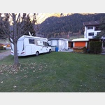
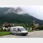
Pictures of the place and surroundings
.
Interesting places in the area
Camping Andeer
 The campsite is not far from the river and is located on the outskirts
is open 1 January - 31 December
[ click for more information ]
Parkenpkw
[ click for more information ]Parkenwomo8
[ click for more information ]Rofflaschlucht
Roffla Gorge with a waterfall under which you can walk.[ click for more information ]
Raiffeisen Donat
[ click for more information ]ParkenAll
[ click for more information ]Parkplatz Nislas 104
 Place near the famous and worth seeing church (with museum) of Zilis at the end of Via Mala, starting point for hikes Arrival: Coming from Germany: Exit Via Mala Busparkplatz
[ click for more information ]