GIS24.net
Geographic Information System
POI database from MEINWOMOmaps


Geographic Information System
POI database from MEINWOMOmaps
Mathon GR
/
ADDRESS

WeiterUrl : https:/ / de.wikipedia.org/ wiki/ Mathon GR
UrlLoad : https:/ / yes
WikiText : Mathon (rätoromanisch Maton) ist eine politische Gemeinde im Kreis Schams im Bezirk Hinterrhein des Kantons Graubünden in der Schweiz. Beschreibung: In Rot eine goldene (gelbe) Glocke. Nach der Beschreibung des Dorfes als: "La vischnaunca dils buons zenns" d. h. das Dorf mit den guten Glocken. Die Gemeinde liegt auf einer Terrasse am Ostabhang des Piz Beverin westlich von Donat. Vom gesamten Gemeindegebiet von über 15 ,km sind 1002 ,ha landwirtschaftlich nutzbar, zum Grossteil als Maiensässen (Alpwirtschaften). Weitere 337 ,ha sind unproduktive Fläche (fast ausschliesslich Gebirge), 152 ,ha sind von Wald und Gehölz bedeckt und der Rest von 21 ,ha ist Siedlungsfläche.
Click for interactive map
..
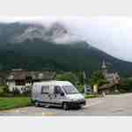
Pictures of the Poi and surroundings
.
Things to see in the area
Raiffeisen Donat
[ click for more information ]Wanderparkplatz
[ click for more information ]Parkplatz Nislas 104
 Place near the famous and worth seeing church (with museum) of Zilis at the end of Via Mala, starting point for hikes Arrival: Coming from Germany: Exit Via Mala Busparkplatz
[ click for more information ]
ParkenAll
[ click for more information ]Parkenpkw
[ click for more information ]ParkenAll
[ click for more information ]Cufercalhütte
The Cufercalhütte is located in the Beverin Nature Park, above Sufers in the canton of Graubünden at 2385 m above sea level.[ click for more information ]