GIS24.net
Geographic Information System
POI database from MEINWOMOmaps


Geographic Information System
POI database from MEINWOMOmaps
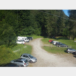
Dalpe
/
ADDRESS

WeiterUrl : https:/ / de.wikipedia.org/ wiki/ Dalpe
UrlLoad : https:/ / yes
WikiText : Dalpe ist eine politische Gemeinde im Bezirk Leventina des Kantons Tessin in der Schweiz. Das Bergdorf Dalpe liegt auf einer Hochebene am Eingang des Val Piumogna, welches ein rechtes Seitental des Valle Leventina ist. Dazu gehört auch der kleine Weiler Cornone, welcher mit Dalpe die gleichnamige Gemeinde bildet. Dalpe ist die südlichste Gemeinde des oberen Teils der Leventina (Alta Leventina) und gehört mit den Gemeinden Prato Leventina und Quinto zum Circolo di Quinto. 1866 haben sich Dalpe und Cornone von Prato getrennt.
Click for interactive map
..
Pictures of the Poi and surroundings
.
Things to see in the area
Supermarkt Carrefour
[ click for more information ]Cascata della Piumogna
In the village of Faido there are small signs for Cascata Piumogna.[ click for more information ]
Seilbahn Rodi - Lago Tremorgio
 2255616_Beschreibung
[ click for more information ]
Passo Vanitt
Der Passo Vanitt ist ein Gebirgspass in der Leventina im Kanton Tessin.[ click for more information ]
Capanna Campo Tencio
The hut is located on a mountain terrace at 2140 m.[ click for more information ]
Capanna Tremorgio
The hut is located on Lago Tremorgio at 1851m.[ click for more information ]
Lago di Leit
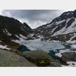 kristallklarer Bergsee auf 2´300 m Höhe,direkt an der bewirtschafteten Capanna Leit
[ click for more information ]
Capanna Leit
The hut is located in Valle Leventina at Passo Campolungo at 2257m.[ click for more information ]
Rifugio Alpe Sponda
The hut is in the Val di Chironico at 1997m.[ click for more information ]
Capanna Prodör
The hut is located in Valle Leventina at 1740m.[ click for more information ]