GIS24.net
Geographic Information System
POI database from MEINWOMOmaps


Geographic Information System
POI database from MEINWOMOmaps
Clugin
/
ADDRESS

WeiterUrl : https:/ / de.wikipedia.org/ wiki/ Clugin
UrlLoad : https:/ / yes
WikiText : Clugin (rätoromanisch Clugen) war bis zum 31. Dezember 2008 politische Gemeinde im Kanton Graubünden, Schweiz. Sie gehörte zum Kreis Schams im Bezirk Hinterrhein und war nach Andeer orientiert. Clugin war eine der kleinsten selbstständigen Gemeinden der Schweiz. Die ehemalige Gemeinde zählte auch im 19. Jahrhundert nie mehr als 80 Einwohner. Sie bildet ein Haufendorf und liegt am Fusse des Schamserbergs. Auf den 1. Januar 2009 hat Clugin mit Pignia und Andeer zur Gemeinde Andeer fusioniert.
Click for interactive map
..
Pictures of the Poi and surroundings
.
Things to see in the area
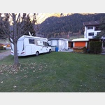
Parkenpkw
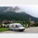
[ click for more information ]Camping Andeer
 The campsite is not far from the river and is located on the outskirts
is open 1 January - 31 December
[ click for more information ]
Raiffeisen Donat
[ click for more information ]ParkenAll
[ click for more information ]Parkplatz Nislas 104
 Place near the famous and worth seeing church (with museum) of Zilis at the end of Via Mala, starting point for hikes Arrival: Coming from Germany: Exit Via Mala Busparkplatz
[ click for more information ]
ParkenAll
[ click for more information ]Parkenwomo8
[ click for more information ]Rofflaschlucht
Roffla Gorge with a waterfall under which you can walk.[ click for more information ]