GIS24.net
Geographic Information System
POI database from MEINWOMOmaps


Geographic Information System
POI database from MEINWOMOmaps
Alvaneu
/
ADDRESS

WeiterUrl : https:/ / de.wikipedia.org/ wiki/ Alvaneu
UrlLoad : https:/ / yes
WikiText : Alvaneu, rätoromanisch Alvagni, ist eine politische Gemeinde im Kreis Belfort des Bezirks Albula im Kanton Graubünden in der Schweiz. Die vier anderen Gemeinden des Kreises Belfort sind Brienz/Brinzauls, Surava, Schmitten und Lantsch/Lenz. Alvaneu ist ein Haufendorf in 1181 ,m Höhe auf einer Terrasse nördlich des Albulatales an der Kantonsstrasse zwischen Lenzerheide und Davos, aufgeteilt in Alvaneu Dorf am Hang und Alvaneu Bad im Talboden. Die traditionelle Sprache der Bevölkerung war bis Mitte des 19. ,Jahrhunderts Surmeirisch, eine regionale Mundart des Romanischen. Bereits 1880 gaben nur noch 80 ,% der Einwohnerschaft Romanisch als Muttersprache an. Dieser Erosionsprozess setzte sich fort (1910: 68 ,%, 1941: 56 ,%, 1970: 47 ,%). 1960 war die letzte Volkszählung mit romanischer Bevölkerungsmehrheit, 1970 waren diese noch eine relative Mehrheit. Seit 1980 hat die deutsche Sprache ein ständig grösser werdendes bergewicht erlangt, wie folgende Tabelle zeigt:
Click for interactive map
..
Pictures of the Poi and surroundings
.
Things to see in the area
Parkenwander
[ click for more information ]Golf Club Alvaneu
18 hole course at almost 1000m.[ click for more information ]
Autowaschanlage
[ click for more information ]Parkplatz am Landwasserviadukt
 Unpaved car park to visit the Landwasser Viaduct.
 [ click for more information ]
Schaftobelfall
Der Schaftobelfall ist von Alvaneu Bad oder Surava erreichbar.[ click for more information ]
Rüti Ranch
1/2 day or 2 day tours in the Albula Valley/Grisons.[ click for more information ]
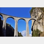
Landwasserviadukt
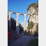 The Albula Railway (UNESCO World Heritage Site) crosses this arched bridge made of dark limestone.
 [ click for more information ]
Parkenwander
[ click for more information ]Campingplatz Islas
A beautifully located campsite at an altitude of approxopen 1 April - 31 October
[ click for more information ]
Ramozhütte
It lies at the foot of the Erzhorn above Arosa on Alp Ramoz at an altitude of 2293 m above sea level.[ click for more information ]
Furcletta
With a pass height of 2573 m, it connects Arosa in Schanfigg with Alvaneu and Schmitten GR in the Albula Valley[ click for more information ]