GIS24.net
Geographic Information System
POI database from MEINWOMOmaps


Geographic Information System
POI database from MEINWOMOmaps
Wila
/
ADDRESS

WeiterUrl : https:/ / de.wikipedia.org/ wiki/ Wila
UrlLoad : https:/ / yes
WikiText : Wila ist eine politische Gemeinde im Bezirk Pfäffikon des Kantons Zürich in der Schweiz. Blasonierung Das Wappen wurde vom Schild der Herren von Breiten-Landenberg übernommen.
Click for interactive map
..
Pictures of the Poi and surroundings
Videos about the Poi and the surrounding area
.
.
Things to see in the area
Bahnhof Wila
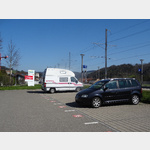 A parking lot at Wila train station
 usable 1 January - 31 December
[ click for more information ]
Kugelgasse 4 , Wila, Schweiz
[ click for more information ]Ortsmuseum Wila
The local museum presents the history of the community and organizes special exhibitions and events every year.[ click for more information ]
Bodenweiher
Der Bodenweiher liegt im zürcherischen Wila auf 589 Metern.[ click for more information ]
Müliweiher
Der Müliweiher ist ein kleiner Weiher auf dem Gebiet der Zürcher Gemeinde Wila auf 590m.[ click for more information ]
Parkplatz Tablat
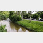 TCS hiking car park located on the Töss
usable January - December
[ click for more information ]
Bahnhof Turbenthal
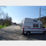 Parking at Turbenthal train station
is open 1 January - 31 December
[ click for more information ]
TCS Parkplatz AU
 located behind the river
is open January - December
[ click for more information ]
Ortsmuseum Turbenthal
Focus on local history, industrialization and industrialization.[ click for more information ]
Volg
with postal agency[ click for more information ]
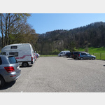
Parkplatz Gyrenbad
Hiking car park in Gyrenbad above Turbenthal.[ click for more information ]
Alpaka-Zürich-Oberland
Alpaca trekking with snack or fondue[ click for more information ]
Himmerichweiher
Der Himmerichweiher liegt in der Zürcher Gemeinde Zell auf einer Höhe von 519 Metern.[ click for more information ]
Strandbad Bichelsee
unbewachter Badeplatz.[ click for more information ]