GIS24.net
Geographic Information System
POI database from MEINWOMOmaps


Geographic Information System
POI database from MEINWOMOmaps
St. Peterzell
/
ADDRESS

WeiterUrl : https:/ / de.wikipedia.org/ wiki/ St. Peterzell
UrlLoad : https:/ / yes
WikiText : St. Peterzell war bis zum 31. Dezember 2008 eine politische Gemeinde im Wahlkreis Toggenburg des Kantons St. Gallen in der Schweiz. In der Abstimmung vom 21. Oktober 2007 stimmten die Einwohner für eine Fusion mit Brunnadern und Mogelsberg zur neuen Gemeinde Neckertal per 1. Januar 2009. St. Peterzell liegt am Fluss Necker. Die Nachbargemeinden waren Hemberg SG, Schönengrund, Schwellbrunn und Degersheim SG.
Click for interactive map
..
Pictures of the place and surroundings
.
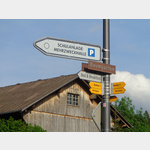
Interesting places in the area
St. Peterzell Zentrum
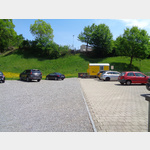 Parking at the depot and near the church
[ click for more information ]
Parkplatz Mehrzweckhalle
 Parking at the multipurpose hall
[ click for more information ]
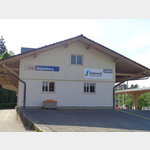
Raiffeisen Hemberg
[ click for more information ]Badweiher
Der malerische Badweiher liegt in der Toggenburger Gemeinde Hemberg auf 965 Metern.[ click for more information ]
Skilift Hemberg
 Parking at the Hemberg ski lift.
 [ click for more information ]
Mistelegg
 Mistelegg car park, municipality of Hemberg.
 [ click for more information ]
Bahnhof Brunnadern
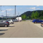 Parking lot at Brunnadern train station
[ click for more information ]
Mogelsberg Bahnhof
 Parking at the train station
[ click for more information ]
Mogelsberg Ochsenplatz
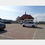 Ochsenplatz car park in the village centre.
 [ click for more information ]
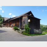
Ackerhus
The Ackerhus Museum in a Toggenburg house from the 18th century shows collections of Toggenburg domestic culture from four centuries.[ click for more information ]