GIS24.net
Geographic Information System
POI database from MEINWOMOmaps


Geographic Information System
POI database from MEINWOMOmaps
Alt St. Johann
/
ADDRESS

WeiterUrl : https:/ / de.wikipedia.org/ wiki/ Alt St. Johann
UrlLoad : https:/ / yes
WikiText : Alt St. Johann (franz.: Saint-Jean-le-Vieux) ist eine politische Gemeinde im Kanton St. Gallen. Sie befindet sich im Wahlkreis Toggenburg im Thurtal. Zu Alt St. Johann gehören die Ortschaften Alt St. Johann, Unterwasser und Starkenbach. Auf den 1. Januar 2010 fusionieren die Gemeinden Wildhaus und Alt St. Johann zur neuen Gemeinde Wildhaus-Alt St. Johann. Alt St. Johann ist die zweitoberste Gemeinde im Toggenburg. Die Dörfer Alt St. Johann und Unterwasser liegen im oberen Thurtal. Im Gemeindegebiet liegen die Churfirsten und Teile des Alpsteins. Die Gebirge gehören zu den Appenzeller Alpen. Der höchste Punkt der Gemeinde ist der Hinterrugg mit 2306 m.ü.M. Die Nachbargemeinden sind Wildhaus, Nesslau-Krummenau, Stein SG, Amden, Quarten, Walenstadt und Grabs.
Click for interactive map
..
Pictures of the Poi and surroundings
.
Things to see in the area
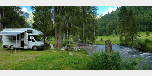
Camping Thur
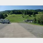 Small campsite opposite the Sellamatt cable car
is open January - December
[ click for more information ]
Klangwelt Toggenburg
Since 2003, activities and offers have been combined under the name Klangwelt Toggenburg, which convey the most important forms of this musical culture and show the relationship to traditions all over the world.[ click for more information ]
Parkplatz Iltiosbahn
Grosser Parkplatz neben der Talstation[ click for more information ]
Gräppelensee
Der Gräppelensee befindet sich oberhalb von Unterwasser in der Gemeinde Wildhaus-Alt St.[ click for more information ]
Parkplatz Unterwasser
Öffentlicher Parkplatz vor dem Hotel Säntis[ click for more information ]
Wildmannli Hütte
Einfache Hütte auf der Alp Strichboden.[ click for more information ]
Huskystuff
Husky trekking with sleds.[ click for more information ]
Thurfälle
Unter der Bezeichnung Thurfälle versteht man die zweistufige Kaskade der Säntisthur (Fluss).[ click for more information ]
Alp Tschingla
Alp Tschingla is located at 1528m above sea level, in the middle of the Churfirsten.[ click for more information ]
Toggenburger Lama Trekking
Llama trekking from May-Oct.[ click for more information ]
Waldparkplatz Laui
 A very nice, shady, absolutely quiet, level forest parking lot lying on a stream.
 [ click for more information ]
Alp Schrina
Alpine hut at 1285m on the Walenstadterberg.[ click for more information ]
Vorderer Schwendisee
Der Schwendisee befindet sich oberhalb der Dörfer Wildhaus und Unterwasser im Toggenburg im Kanton St.[ click for more information ]
Hinterer Schwendisee
Er liegt in der Gemeinde Wildhaus-Alt St.[ click for more information ]
Bergrestaurant Lüsis
Mountain restaurant above Walenstadt.[ click for more information ]