GIS24.net
Geographic Information System
POI database from MEINWOMOmaps


Geographic Information System
POI database from MEINWOMOmaps
Stosswihr
/
ADDRESS
68140 StosswihrChemin de Soultzeren
WeiterUrl : https:/ / de.wikipedia.org/ wiki/ Stosswihr
UrlLoad : https:/ / yes
WikiText : Stosswihr (deutsch Stoßweier) ist eine elsässische Gemeinde im französischen Dpartement Haut-Rhin. Das Dorf liegt in den Vogesen, im Valle de la Petite Fecht, einem Seitental des Valle de Munster, etwa 20 km von Colmar im Osten und 25 ,km von Grardmer im Westen entfernt. Stosswihr liegt auch im Kern des Regionalen Naturparks Ballons des Vosges (frz. ,Parc naturel rgional des Ballons des Vosges). In einem Dokument aus dem Jahr 783 wird das Dorf unter dem Namen Stozzeswillars zum ersten Mal erwähnt. Stosswihr kam während des Dreißigjährigen Krieges zum Elsass. Im Februar 1915, während des Ersten Weltkriegs, wurde die Talschaft durch die Invasion deutscher Truppen stark in Mitleidenschaft gezogen. Mit dem Wiederaufbau wurde 1920 begonnen.
Click for interactive map
..
Pictures of the place and surroundings
.
Interesting places in the area
Salle des Fetes
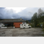 Large car park at the Festhalle of Stosswihr
usable January - December
[ click for more information ]
Parkenpkw
[ click for more information ]Parkenpkw
[ click for more information ]Reichsackerkopf 778 m
[ click for more information ]La Gare, 68140 Luttenbach-près-Munster, France
[ click for more information ]Camping Les Amis de la Nature
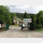 A beautifully situated campsite about 2
is open 21 March - 12 November
[ click for more information ]
Parkenpkw
[ click for more information ]La Gare, 68380 Breitenbach-Haut-Rhin, France
[ click for more information ]Parkplatz D5B1
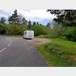 Panoramic views, trekking routes
[ click for more information ]
TouristInfo
Office de Tourisme[ click for more information ]
Le Linge 1914-1918
Museum and trenches at a loss-making battlefield from the First World War.[ click for more information ]
Total
2271491_Beschreibung[ click for more information ]