GIS24.net
Geographic Information System
POI database from MEINWOMOmaps


Geographic Information System
POI database from MEINWOMOmaps
Haidmühle
/
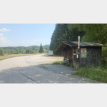
ADDRESS
HaidmühleMax-Pangerl-Straße
WeiterUrl : https:/ / de.wikipedia.org/ wiki/ Haidmühle
UrlLoad : https:/ / yes
WikiText : 1.421 (31. ,Dez. ,2008)[1] Haidmühle ist eine Gemeinde im niederbayerischen Landkreis Freyung-Grafenau und staatlich anerkannter Erholungsort. Die Gemeinde liegt in der Region Donau-Wald an der Kalten Moldau im Bayerischen Wald, direkt an der Grenze zu Tschechien an der Glasstraße. Haidmühle befindet sich 25 km von Freyung, 24 km von Waldkirchen und 20 km von der Grenze zu sterreich entfernt.
Click for interactive map
..
Pictures of the Poi and surroundings
.
Things to see in the area
Hotel Haidmühle
Relatively quiet, level and very spacious car park near the Hotelgasthof Strohmaier.[ click for more information ]
Haidmühle
[ click for more information ]Parkenprivat
[ click for more information ]Adalbert-Stifter-Radweg
Adalbert Stifter cycle path: Waldkirchen - Haidmühle[ click for more information ]
besuch
[ click for more information ]Neuthaler Straße
 Large parking lot at the edge of the forest approx
open January - December
[ click for more information ]
Eisenbahnmuseum Neuthal
Nove Udoli[ click for more information ]
Die Moldau von den Quellen bis zur Mündung
The sources are in the German-Czech border area.[ click for more information ]
Goldsteig, Nordroute 21 Haidmuehle Breitenberg
The hiking trail leads through the Bavarian Forest and the Upper Palatinate Forest.[ click for more information ]
Kalte Moldau
The Cold Moldau is formed west of Haidmühle through the confluence of the left Weberaubach and right Rothbach[ click for more information ]
Branntweinhäuser
Hiking car park on the Adalbert-Stifter footpath and cycle path[ click for more information ]