GIS24.net
Geographic Information System
POI database from MEINWOMOmaps


Geographic Information System
POI database from MEINWOMOmaps
Chlumec u ChabaÅovic
/
ADDRESS

WeiterUrl : https:/ / de.wikipedia.org/ wiki/ Chlumec u ChabaÅovic
UrlLoad : https:/ / yes
WikiText : Chlumec (deutsch Kulm) ist eine Gemeinde in Tschechien. Sie befindet sich fünf Kilometer nordöstlich von Krupka und gehört zum Okres st nad Labem. Der Ort am Chlumeck potok liegt am südlichen Fuße des Osterzgebirges unterhalb des Mraven vrch (557 ,m). Hausberg von Chlumec ist der Horka (Kapellenberg) am nordöstlichen Ortsrand. Nachbarorte sind Stradov und Pestanov im Westen, Chabaovice und esk jezd im Süden sowie andov im Nordosten. Chlumec liegt an der Staatsstraße 13 von Teplice nach Dn, von der am Ortsrand die Staatsstraße 30 nach st nad Labem abzweigt. Die Straßenführung von Teplice nach st nad Labem ist gleichzeitig Teil der Europastraße 442. Nördlich verläuft die Bahnstrecke DnChomutov.
Click for interactive map
..
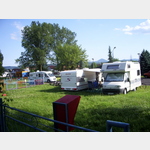
Pictures of the Poi and surroundings
.
Things to see in the area
Parkenwander
[ click for more information ]Parkenprivat
[ click for more information ]Parkenwander
[ click for more information ]Parkenwander
[ click for more information ]Autokemp Chabarovice
 Located on a small lake on the edge of the village
 is open 1 May - 31 October
[ click for more information ]
KJB KOMPLEX Úst¡ nad Labem/24h/bar,EC,KreditK/EUR
[ click for more information ]Zechberg 796 m
[ click for more information ]Parkplatz
[ click for more information ]McDonald
[ click for more information ]Einkaufsparkplatz
[ click for more information ]Restaurant McDonalds, Tschechien, �st� nad Labem K Zahr�dk�m 1
[ click for more information ]
[ click for more information ]