GIS24.net
Geographic Information System
POI database from MEINWOMOmaps


Geographic Information System
POI database from MEINWOMOmaps
Thusis
/
ADDRESS

WeiterUrl : https:/ / de.wikipedia.org/ wiki/ Thusis
UrlLoad : https:/ / yes
WikiText : Thusis (im einheimischen Dialekt: [t(h)ui], rätorom. Tus¡un, ital. Tosana)[2] ist eine politische Gemeinde im Kanton Graubünden (Schweiz) und gleichzeitig Hauptort des gleichnamigen Kreises. Beschreibung: In Rot ein aufrechter goldener Löwe mit Doppelquaste, in der rechten Vorderpranke ein goldenes Lilienzepter haltend. Das Wappen beruht auf dem Gerichtssiegel des Heinzenbergs aus dem Jahr 1584. Die Gemeinde Thusis liegt am nördlichen Eingang zur Via-Mala-Schlucht. Die Gemeinde grenzt im Westen an den Heinzenberg und im Osten an den Hinterrhein und an das rechtsrheinisch angrenzende Domleschg.
Click for interactive map
..
Pictures of the Poi and surroundings
.
Things to see in the area
Spital Thusis
Phone: 41 (0)81 632 11 11[ click for more information ]
coop
[ click for more information ]Bahnhof Thusis
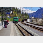 Rhaetian Railway station in Thusis.
 [ click for more information ]
Raiffeisen Thusis
[ click for more information ]Migros
[ click for more information ]sonstiges
[ click for more information ]Autowaschanlage
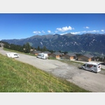
[ click for more information ]TCS Camping Thusis - Viamala
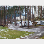 Very nice newly revised course
usable January - December
[ click for more information ]
Parkplatz beim Waldschwimmbad
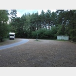 Quiet place in the forest.
 [ click for more information ]
sonstiges
Follow the signs to the ´Thusis petrol station´, within the large parking area an area for mobile homes is marked.[ click for more information ]
Thusis - Nord Raststätte Viamals
 Large parking area with RV and teams
open 1 January - 31 December
[ click for more information ]
Parkplatz Skilift Oberurmein
 Quiet parking lot in the place of the ski lift.
 [ click for more information ]