GIS24.net
Geographic Information System
POI database from MEINWOMOmaps


Geographic Information System
POI database from MEINWOMOmaps
Bauma ZH
/
ADDRESS

WeiterUrl : https:/ / de.wikipedia.org/ wiki/ Bauma ZH
UrlLoad : https:/ / yes
WikiText : Bauma ist eine politische Gemeinde im Bezirk Pfäffikon des Kantons Zürich in der Schweiz. Blasonierung Bauma liegt im Zürcher Oberland und im voralpinen Teil des Tösstales auf 640 ,m ,ü. ,M. an der Bahnlinie Winterthur-Rapperswil. Sein höchster Punkt ist das Chli-Hörnli mit 1073 ,m ,ü. ,M..
Click for interactive map
..
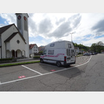
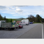
Pictures of the Poi and surroundings
.
Things to see in the area
Migros
[ click for more information ]Dampfbahn-Verein Zürcher Oberland
Historic steam trains operate on the Bauma - Hinwil route[ click for more information ]
Bauma
[ click for more information ]Tosstal-Apotheke
[ click for more information ]SBB Bahnhof Bauma
 the train station is in the center of Bauma
usable 1 January - 31 December
[ click for more information ]
TCS Parkplatz Neuthal
 A car park behind the old train station which is no longer in use
is open 1 January - 31 December
[ click for more information ]
Alpaka-Zürich-Oberland
Alpaca trekking with snack or fondue[ click for more information ]
Volg
with postal agency[ click for more information ]
Luppmenweiher
Der Luppmenweiher ist ein Waldweiher südlich des Hittnauer Dorfzentrums auf einer Höhe von 700 Metern[ click for more information ]
Alti Sagi Stockrüti
The last sawmill in the Zurich Oberland powered by a water wheel is located in Stöckrüti near Wappenswil at an altitude of more than 800 meters.[ click for more information ]
Ghöch
Der Pass führt auf einer Nebenstrasse auf eine Höhe von 962m von Bäretswil nach Gibswil.[ click for more information ]
Bodenweiher
Der Bodenweiher liegt im zürcherischen Wila auf 589 Metern.[ click for more information ]