GIS24.net
Geographic Information System
POI database from MEINWOMOmaps


Geographic Information System
POI database from MEINWOMOmaps
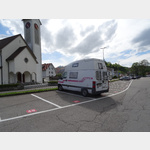
Ruine Alt-Landenberg
Castle / Ruins
ADDRESS
 8494 Bauma
Husacherstrasse
Facilities :
 Open to the
 Click for interactive map
..
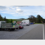
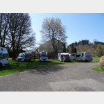
Pictures of the Poi and surroundings
.
Things to see in the area
Dampfbahn-Verein Zürcher Oberland
Historic steam trains operate on the Bauma - Hinwil route[ click for more information ]
SBB Bahnhof Bauma
 the train station is in the center of Bauma
open 1 January - 31 December
[ click for more information ]
TCS Parkplatz Neuthal
 A car park behind the old train station which is no longer in use
is open 1 January - 31 December
[ click for more information ]
Alpaka-Zürich-Oberland
Alpaca trekking with snack or fondue[ click for more information ]
Camping Saland
 A campsite with mostly long-term campers, at approx
open 1 January - 31 December
[ click for more information ]
Volg
with postal agency[ click for more information ]
Luppmenweiher
Der Luppmenweiher ist ein Waldweiher südlich des Hittnauer Dorfzentrums auf einer Höhe von 700 Metern[ click for more information ]
Bodenweiher
Der Bodenweiher liegt im zürcherischen Wila auf 589 Metern.[ click for more information ]
Alti Sagi Stockrüti
The last sawmill in the Zurich Oberland powered by a water wheel is located in Stöckrüti near Wappenswil at an altitude of more than 800 meters.[ click for more information ]
Ghöch
Der Pass führt auf einer Nebenstrasse auf eine Höhe von 962m von Bäretswil nach Gibswil.[ click for more information ]
Humbelweiher
Der Humbelweiher liegt auf dem Gemeindegebiet von Hittnau im Kanton Zürich auf einer Höhe von 692 Metern.[ click for more information ]
Ortsmuseum Wila
The local museum presents the history of the community and organizes special exhibitions and events every year.[ click for more information ]
Müliweiher
Der Müliweiher ist ein kleiner Weiher auf dem Gebiet der Zürcher Gemeinde Wila auf 590m.[ click for more information ]