GIS24.net
Geographic Information System
POI database from MEINWOMOmaps


Geographic Information System
POI database from MEINWOMOmaps
Ruine "Alt Wädenswil"
Castle /
ADDRESS
 8805 Richterswil
Click for interactive map
..
Pictures of the Poi and surroundings
.
Things to see in the area
Parking castle ruins
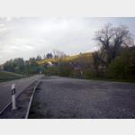 Gravelled parking area at a moderate to low traffic street
usable January - December
[ click for more information ]
Reidbachweiher
Der Reidbachweiher befindet sich auf dem Stadtgebiet von Wädenswil im Kanton Zürich auf 471 Metern.[ click for more information ]
Seeuferweg Turm
[ click for more information ]parking spot
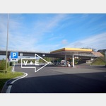
of Zürüch towards Chur to the A3 driveway, first comes the rest house, about a scarcer km after the campers service parking lot with restroomsopen January - December
[ click for more information ]
Sagi Samstagern
The sawmill in Saturdayern has been using the water power of the Sagibach since 1656.[ click for more information ]
Ortsmuseum Richterswil
The Richterswil local museum deepens the understanding of regional history and promotes cultural life in the community.[ click for more information ]
Highway rally Herrlisberg, Chur - Zurich
 Only on the direction of travel from Chur to Zurich
open January - December
[ click for more information ]
Freyenweiher
Auch Itlimoosweiher genannt.[ click for more information ]
Weingartenweiher
Die Höhe des Weingartenweihers wird mit 492 Metern angegeben.[ click for more information ]
Volg
with postal agency[ click for more information ]
Kletterzentrum Gaswerk Wädenswil
Climbing, climbing courses[ click for more information ]
Ausee
Der Ausee befindet sich auf der Halbinsel Au auf dem Gebiet der Gemeinde Wädenswil im Kanton Zürich.[ click for more information ]
Adolf Bolliger Weiher
Der Adolf Bolliger Weiher befindet sich in Oetwil am Zürichsee.[ click for more information ]